Etāwah geodata
Etāwah (Uttar Pradesh) is a populated place; located in India in Asia/Kolkata (GMT+5.5) time zone. With population of 257,448 people, there are 166 cities with bigger population in this country. Compared to other cities in India, 76.7% of cities are located further ↓South; 59.2% of cities are located further ←West and 58.7% of cities have higher elevation than Etāwah. Note1


Etāwah GPS coordinates[2]
26° 46' 34.14" North, 79° 1' 16.788" East
| Map corner | latitude | longitude |
|---|---|---|
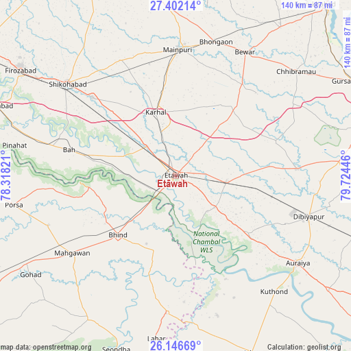
| Upper-left | 27.40214°, | 78.31821° |
| Center: | 26.77615°, | 79.02133° |
| Lower-right: | 26.14669°, | 79.72446° |
| Map W x H: | 139.6×139.6 km | = 86.7×86.7mi |
| max Lat: | 34.9274° ⇑23.3% North |
| Etāwah: | 26.77615° |
| min Lat: | ⇓76.7% South 8.09008° |
| min Long | Etāwah | max Long |
| 68.82655° | 79.02133° | 96.81° |
| W 59.2%⇐ | ⇒40.8% E |
Elevation
Elevation of Etāwah is 154 m = 505 ft, and this is 141.6 m = 465 ft below average elevation for this country.
| Max E: |
3681 m = 12077 ft | 58.7% |
| Avg. | 295.6 m = 970 ft | |
| Etāwah | 154 m = 505 ft | |
Min E: |
1 m = 3 ft | 41.3% |
See also: Etāwah elevation on elevation.city.
Geographical zone
Etāwah is located in North temperate zone (between Tropic of Cancer and the Arctic Circle). Distance of this Northern Tropic circle is 371.3 km =230.7 mi to South.| Distance of | km | miles | from Etāwah |
|---|---|---|---|
| North Pole | 7029.8 | 4368.1 | to North |
| Arctic Circle | 4423.9 | 2748.9 | to North |
| Tropic Cancer | 371.3 | 230.7 | to South |
| Equator | 2977.2 | 1849.9 | to South |


Nearby cities:
15 places around Etāwah: (largest is in red/bold)
• Bakewar
19.9 km =12.4 mi,  129°
129°
• Bharthana
20.1 km =12.5 mi,  97°
97°
• Bhind
32.9 km =20.4 mi,  224°
224°
• Bidhūna
48.4 km =30.1 mi,  86°
86°
• Bāh
43.7 km =27.2 mi,  283°
283°
• Jaswantnagar
16.7 km =10.4 mi,  315°
315°
• Karhal
26.3 km =16.3 mi,  341°
341°
• Kishni
36.5 km =22.7 mi,  40°
40°
• Lakhnā
19 km =11.8 mi,  138°
138°
• Nagla Panchi
38.8 km =24.1 mi,  14°
14°
• Phaphūnd
48.2 km =30 mi,  114°
114°
• Rāmpura
50.1 km =31.1 mi,  161°
161°
• Sarai Ekdil
8 km =5 mi,  116°
116°
• Sirsāganj
45.6 km =28.3 mi,  313°
313°
• Umri
30.7 km =19.1 mi,  195°
195°
Sources, notices
• [Note1] Compared only with cities in India existing in our database
• [Src1] Map data: © OpenStreetMap contributors (CC-BY-SA)
• [Src2] Other city data from geonames.org with taken over terms of usage.
• [Src3] Geographical zone / Annual Mean Temperature by Robert A. Rohde @ Wikipedia
