Karhal geodata
Karhal (Uttar Pradesh) is a populated place; located in India in Asia/Kolkata (GMT+5.5) time zone. With population of 26,693 people, there are 1598 cities with bigger population in this country. Compared to other cities in India, 78.3% of cities are located further ↓South; 58.5% of cities are located further ←West and 57.6% of cities have higher elevation than Karhal. Note1


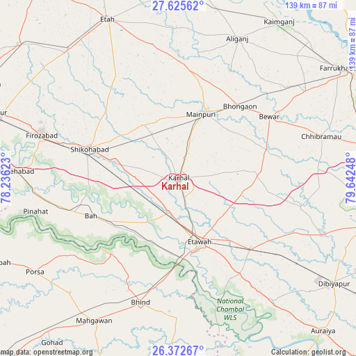
Karhal GPS coordinates[2]
27° 0' 3.204" North, 78° 56' 21.66" East
| Map corner | latitude | longitude |
|---|---|---|
| Upper-left | 27.62562°, | 78.23623° |
| Center: | 27.00089°, | 78.93935° |
| Lower-right: | 26.37267°, | 79.64248° |
| Map W x H: | 139.3×139.3 km | = 86.6×86.6mi |
| max Lat: | 34.9274° ⇑21.7% North |
| Karhal: | 27.00089° |
| min Lat: | ⇓78.3% South 8.09008° |
| min Long | Karhal | max Long |
| 68.82655° | 78.93935° | 96.81° |
| W 58.5%⇐ | ⇒41.5% E |
Elevation
Elevation of Karhal is 160 m = 525 ft, and this is 135.6 m = 445 ft below average elevation for this country.
| Max E: |
3681 m = 12077 ft | 57.6% |
| Avg. | 295.6 m = 970 ft | |
| Karhal | 160 m = 525 ft | |
Min E: |
1 m = 3 ft | 42.4% |
See also: India elevation on elevation.city.
Geographical zone
Karhal is located in North temperate zone (between Tropic of Cancer and the Arctic Circle). Distance of this Northern Tropic circle is 396.3 km =246.2 mi to South.| Distance of | km | miles | from Karhal |
|---|---|---|---|
| North Pole | 7004.8 | 4352.6 | to North |
| Arctic Circle | 4399 | 2733.4 | to North |
| Tropic Cancer | 396.3 | 246.2 | to South |
| Equator | 3002.2 | 1865.5 | to South |


Nearby cities:
15 places around Karhal: (largest is in red/bold)
• Bewar
42.9 km =26.7 mi,  55°
55°
• Bharthana
39.4 km =24.5 mi,  134°
134°
• Bhongaon
37 km =23 mi,  40°
40°
• Bāh
37.3 km =23.2 mi,  246°
246°
• Etāwah
26.3 km =16.3 mi,  161°
161°
• Ghiror
25.4 km =15.8 mi,  325°
325°
• Jasrāna
38.6 km =24 mi,  312°
312°
• Jaswantnagar
13.6 km =8.5 mi,  195°
195°
• Kishni
32.1 km =19.9 mi,  85°
85°
• Lakhnā
44.3 km =27.5 mi,  152°
152°
• Mainpuri
26.8 km =16.7 mi,  19°
19°
• Nagla Panchi
21.9 km =13.6 mi, 55°
• Sarai Ekdil
32.4 km =20.1 mi, 151°
• Shikohābād
36.9 km =22.9 mi,  288°
288°
• Sirsāganj
25.8 km =16 mi,  284°
284°
Sources, notices
• [Note1] Compared only with cities in India existing in our database
• [Src1] Map data: © OpenStreetMap contributors (CC-BY-SA)
• [Src2] Other city data from geonames.org with taken over terms of usage.
• [Src3] Geographical zone / Annual Mean Temperature by Robert A. Rohde @ Wikipedia
