Bhongaon geodata
Bhongaon (Uttar Pradesh) is a populated place; located in India in Asia/Kolkata (GMT+5.5) time zone. With population of 29,911 people, there are 1449 cities with bigger population in this country. Compared to other cities in India, 80.5% of cities are located further ↓South; 60.8% of cities are located further ←West and 57.1% of cities have higher elevation than Bhongaon. Note1


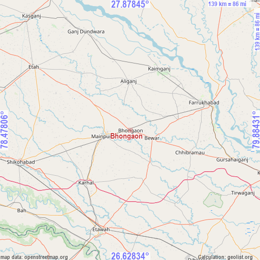
Bhongaon GPS coordinates[2]
27° 15' 18.54" North, 79° 10' 52.248" East
| Map corner | latitude | longitude |
|---|---|---|
| Upper-left | 27.87845°, | 78.47806° |
| Center: | 27.25515°, | 79.18118° |
| Lower-right: | 26.62834°, | 79.88431° |
| Map W x H: | 139×139 km | = 86.4×86.4mi |
| max Lat: | 34.9274° ⇑19.5% North |
| Bhongaon: | 27.25515° |
| min Lat: | ⇓80.5% South 8.09008° |
| min Long | Bhongaon | max Long |
| 68.82655° | 79.18118° | 96.81° |
| W 60.8%⇐ | ⇒39.2% E |
Elevation
Elevation of Bhongaon is 163 m = 535 ft, and this is 132.6 m = 435 ft below average elevation for this country.
| Max E: |
3681 m = 12077 ft | 57.1% |
| Avg. | 295.6 m = 970 ft | |
| Bhongaon | 163 m = 535 ft | |
Min E: |
1 m = 3 ft | 42.9% |
See also: India elevation on elevation.city.
Geographical zone
Bhongaon is located in North temperate zone (between Tropic of Cancer and the Arctic Circle). Distance of this Northern Tropic circle is 424.6 km =263.8 mi to South.| Distance of | km | miles | from Bhongaon |
|---|---|---|---|
| North Pole | 6976.6 | 4335.1 | to North |
| Arctic Circle | 4370.7 | 2715.8 | to North |
| Tropic Cancer | 424.6 | 263.8 | to South |
| Equator | 3030.5 | 1883.1 | to South |


Nearby cities:
15 places around Bhongaon: (largest is in red/bold)
• Alīganj
26.5 km =16.5 mi,  357°
357°
• Bewar
12.2 km =7.6 mi,  109°
109°
• Chhibrāmau
33.7 km =20.9 mi, 110°
• Farrukhābād
42.1 km =26.2 mi,  68°
68°
• Ghiror
39.1 km =24.3 mi,  259°
259°
• Kaimganj
36.6 km =22.7 mi,  24°
24°
• Kampil
40.9 km =25.4 mi,  13°
13°
• Karhal
37 km =23 mi,  220°
220°
• Kishni
26.8 km =16.7 mi,  162°
162°
• Mainpuri
15.3 km =9.5 mi, 258°
• Muhammadābād
25.5 km =15.8 mi,  76°
76°
• Nagla Panchi
16.8 km =10.4 mi,  200°
200°
• Sakīt
44.4 km =27.6 mi,  296°
296°
• Saurikh
39.3 km =24.4 mi,  129°
129°
• Shamsābād
40.3 km =25 mi,  38°
38°
Sources, notices
• [Note1] Compared only with cities in India existing in our database
• [Src1] Map data: © OpenStreetMap contributors (CC-BY-SA)
• [Src2] Other city data from geonames.org with taken over terms of usage.
• [Src3] Geographical zone / Annual Mean Temperature by Robert A. Rohde @ Wikipedia
