Sarai Ekdil geodata
Sarai Ekdil (Uttar Pradesh) is a populated place; located in India in Asia/Kolkata (GMT+5.5) time zone. With population of 10,594 people, there are 2883 cities with bigger population in this country. Compared to other cities in India, 76.3% of cities are located further ↓South; 59.7% of cities are located further ←West and 59.1% of cities have higher elevation than Sarai Ekdil. Note1


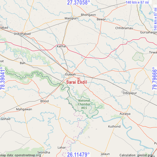
Sarai Ekdil GPS coordinates[2]
26° 44' 39.912" North, 79° 5' 36.708" East
| Map corner | latitude | longitude |
|---|---|---|
| Upper-left | 27.37058°, | 78.39041° |
| Center: | 26.74442°, | 79.09353° |
| Lower-right: | 26.11479°, | 79.79666° |
| Map W x H: | 139.6×139.6 km | = 86.7×86.7mi |
| max Lat: | 34.9274° ⇑23.7% North |
| Sarai Ekdil: | 26.74442° |
| min Lat: | ⇓76.3% South 8.09008° |
| min Long | Sarai Ekdil | max Long |
| 68.82655° | 79.09353° | 96.81° |
| W 59.7%⇐ | ⇒40.3% E |
Elevation
Elevation of Sarai Ekdil is 153 m = 502 ft, and this is 142.6 m = 468 ft below average elevation for this country.
| Max E: |
3681 m = 12077 ft | 59.1% |
| Avg. | 295.6 m = 970 ft | |
| Sarai Ekdil | 153 m = 502 ft | |
Min E: |
1 m = 3 ft | 40.9% |
See also: India elevation on elevation.city.
Geographical zone
Sarai Ekdil is located in North temperate zone (between Tropic of Cancer and the Arctic Circle). Distance of this Northern Tropic circle is 367.8 km =228.5 mi to South.| Distance of | km | miles | from Sarai Ekdil |
|---|---|---|---|
| North Pole | 7033.4 | 4370.4 | to North |
| Arctic Circle | 4427.5 | 2751.1 | to North |
| Tropic Cancer | 367.8 | 228.5 | to South |
| Equator | 2973.7 | 1847.8 | to South |


Nearby cities:
15 places around Sarai Ekdil: (largest is in red/bold)
• Bakewar
12.3 km =7.6 mi,  138°
138°
• Bharthana
12.8 km =8 mi,  86°
86°
• Bhind
36.3 km =22.6 mi,  237°
237°
• Bidhūna
41.7 km =25.9 mi,  81°
81°
• Bāh
51.5 km =32 mi,  285°
285°
• Etāwah
8 km =5 mi,  296°
296°
• Jaswantnagar
24.4 km =15.2 mi,  309°
309°
• Karhal
32.4 km =20.1 mi,  331°
331°
• Kishni
35.4 km =22 mi,  28°
28°
• Lakhnā
12 km =7.5 mi,  153°
153°
• Nagla Panchi
41.1 km =25.5 mi,  3°
3°
• Phaphūnd
40.2 km =25 mi,  113°
113°
• Rāmpura
44.8 km =27.8 mi,  168°
168°
• Saurikh
50.4 km =31.3 mi,  50°
50°
• Umri
30.3 km =18.8 mi,  210°
210°
Sources, notices
• [Note1] Compared only with cities in India existing in our database
• [Src1] Map data: © OpenStreetMap contributors (CC-BY-SA)
• [Src2] Other city data from geonames.org with taken over terms of usage.
• [Src3] Geographical zone / Annual Mean Temperature by Robert A. Rohde @ Wikipedia
