Bakewar geodata
Bakewar (Uttar Pradesh) is a populated place; located in India in Asia/Kolkata (GMT+5.5) time zone. With population of 14,217 people, there are 2537 cities with bigger population in this country. Compared to other cities in India, 75.8% of cities are located further ↓South; 60.7% of cities are located further ←West and 59.5% of cities have higher elevation than Bakewar. Note1


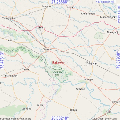
Bakewar GPS coordinates[2]
26° 39' 44.136" North, 79° 10' 34.5" East
| Map corner | latitude | longitude |
|---|---|---|
| Upper-left | 27.28888°, | 78.47313° |
| Center: | 26.66226°, | 79.17625° |
| Lower-right: | 26.03218°, | 79.87938° |
| Map W x H: | 139.7×139.7 km | = 86.8×86.8mi |
| max Lat: | 34.9274° ⇑24.2% North |
| Bakewar: | 26.66226° |
| min Lat: | ⇓75.8% South 8.09008° |
| min Long | Bakewar | max Long |
| 68.82655° | 79.17625° | 96.81° |
| W 60.7%⇐ | ⇒39.3% E |
Elevation
Elevation of Bakewar is 151 m = 495 ft, and this is 144.6 m = 474 ft below average elevation for this country.
| Max E: |
3681 m = 12077 ft | 59.5% |
| Avg. | 295.6 m = 970 ft | |
| Bakewar | 151 m = 495 ft | |
Min E: |
1 m = 3 ft | 40.5% |
See also: India elevation on elevation.city.
Geographical zone
Bakewar is located in North temperate zone (between Tropic of Cancer and the Arctic Circle). Distance of this Northern Tropic circle is 358.6 km =222.8 mi to South.| Distance of | km | miles | from Bakewar |
|---|---|---|---|
| North Pole | 7042.5 | 4376 | to North |
| Arctic Circle | 4436.6 | 2756.8 | to North |
| Tropic Cancer | 358.6 | 222.8 | to South |
| Equator | 2964.6 | 1842.1 | to South |


Nearby cities:
15 places around Bakewar: (largest is in red/bold)
• Auraiya
39.7 km =24.7 mi,  123°
123°
• Bharthana
11 km =6.8 mi,  24°
24°
• Bhind
40.1 km =24.9 mi,  254°
254°
• Bidhūna
36.4 km =22.6 mi,  64°
64°
• Etāwah
19.9 km =12.4 mi,  309°
309°
• Jaswantnagar
36.6 km =22.7 mi, 312°
• Karhal
44.4 km =27.6 mi,  328°
328°
• Kishni
41.2 km =25.6 mi,  11°
11°
• Lakhnā
3.2 km =2 mi,  241°
241°
• Mihona
46.4 km =28.8 mi,  204°
204°
• Mādhogarh
43 km =26.7 mi,  178°
178°
• Phaphūnd
29.5 km =18.3 mi,  103°
103°
• Rāmpura
34.8 km =21.6 mi, 179°
• Sarai Ekdil
12.3 km =7.6 mi,  318°
318°
• Umri
29.2 km =18.1 mi,  234°
234°
Sources, notices
• [Note1] Compared only with cities in India existing in our database
• [Src1] Map data: © OpenStreetMap contributors (CC-BY-SA)
• [Src2] Other city data from geonames.org with taken over terms of usage.
• [Src3] Geographical zone / Annual Mean Temperature by Robert A. Rohde @ Wikipedia
