Khowai geodata
Khowai (Tripura) is a seat of a second-order administrative division; located in India in Asia/Kolkata (GMT+5.5) time zone. With population of 20,046 people, there are 2041 cities with bigger population in this country. Compared to other cities in India, 58.5% of cities are located further ↓South; 96.5% of cities are located further ←West and 84.2% of cities have higher elevation than Khowai. Note1


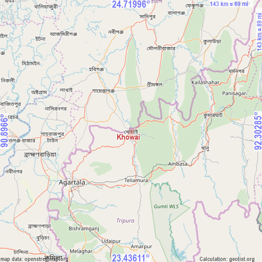
Khowai GPS coordinates[2]
24° 4' 46.704" North, 91° 35' 58.992" East
| Map corner | latitude | longitude |
|---|---|---|
| Upper-left | 24.71996°, | 90.8966° |
| Center: | 24.07964°, | 91.59972° |
| Lower-right: | 23.43611°, | 92.30285° |
| Map W x H: | 142.8×142.8 km | = 88.7×88.7mi |
| max Lat: | 34.9274° ⇑41.5% North |
| Khowai: | 24.07964° |
| min Lat: | ⇓58.5% South 8.09008° |
| min Long | Khowai | max Long |
| 68.82655° | 91.59972° | 96.81° |
| W 96.5%⇐ | ⇒3.5% E |
Elevation
Elevation of Khowai is 33 m = 108 ft, and this is 262.6 m = 862 ft below average elevation for this country.
| Max E: |
3681 m = 12077 ft | 84.2% |
| Avg. | 295.6 m = 970 ft | |
| Khowai | 33 m = 108 ft | |
Min E: |
1 m = 3 ft | 15.8% |
See also: India elevation on elevation.city.
Geographical zone
Khowai is located in North temperate zone (between Tropic of Cancer and the Arctic Circle). Distance of this Northern Tropic circle is 71.5 km =44.4 mi to South.| Distance of | km | miles | from Khowai |
|---|---|---|---|
| North Pole | 7329.7 | 4554.5 | to North |
| Arctic Circle | 4723.8 | 2935.2 | to North |
| Tropic Cancer | 71.5 | 44.4 | to South |
| Equator | 2677.4 | 1663.7 | to South |


Nearby cities:
15 places around Khowai: (largest is in red/bold)
• Agartala
42.3 km =26.3 mi,  230°
230°
• Amarpur
61.9 km =38.5 mi,  174°
174°
• Barjala
57 km =35.4 mi,  205°
205°
• Belonia
93.2 km =57.9 mi,  189°
189°
• Bishramganj
58.8 km =36.5 mi, 206°
• Dharmanagar
65.8 km =40.9 mi,  60°
60°
• Kailāshahar
49.7 km =30.9 mi, 55°
• Kamalpur
27.1 km =16.8 mi, 61°
• Kolasib
110.6 km =68.7 mi,  81°
81°
• Mamit
92 km =57.2 mi,  100°
100°
• Rānīr Bāzār
36.1 km =22.4 mi,  221°
221°
• Sonāmura
75.3 km =46.8 mi, 206°
• Sāitlaw
99.7 km =62 mi, 96°
• Udaipur
61.9 km =38.5 mi, 191°
• Āmbāsa
30.4 km =18.9 mi,  121°
121°
Sources, notices
• [Note1] Compared only with cities in India existing in our database
• [Src1] Map data: © OpenStreetMap contributors (CC-BY-SA)
• [Src2] Other city data from geonames.org with taken over terms of usage.
• [Src3] Geographical zone / Annual Mean Temperature by Robert A. Rohde @ Wikipedia
