Bishramganj geodata
Bishramganj (Tripura) is a seat of a second-order administrative division; located in India in Asia/Kolkata (GMT+5.5) time zone. In our database, there are 3475 cities with bigger population. Compared to other cities in India, 55.4% of cities are located further ↓South; 96.3% of cities are located further ←West and 82.3% of cities have higher elevation than Bishramganj. Note1


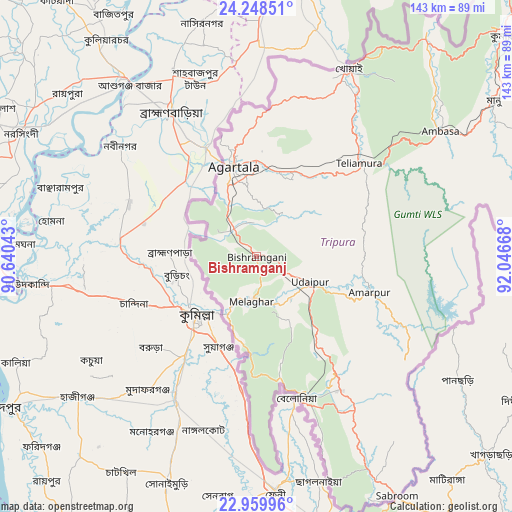
Bishramganj GPS coordinates[2]
23° 36' 20.952" North, 91° 20' 36.78" East
| Map corner | latitude | longitude |
|---|---|---|
| Upper-left | 24.24851°, | 90.64043° |
| Center: | 23.60582°, | 91.34355° |
| Lower-right: | 22.95996°, | 92.04668° |
| Map W x H: | 143.3×143.3 km | = 89×89mi |
| max Lat: | 34.9274° ⇑44.6% North |
| Bishramganj: | 23.60582° |
| min Lat: | ⇓55.4% South 8.09008° |
| min Long | Bishramganj | max Long |
| 68.82655° | 91.34355° | 96.81° |
| W 96.3%⇐ | ⇒3.7% E |
Elevation
Elevation of Bishramganj is 39 m = 128 ft, and this is 256.6 m = 842 ft below average elevation for this country.
| Max E: |
3681 m = 12077 ft | 82.3% |
| Avg. | 295.6 m = 970 ft | |
| Bishramganj | 39 m = 128 ft | |
Min E: |
1 m = 3 ft | 17.7% |
See also: India elevation on elevation.city.
Geographical zone
Bishramganj is located in North temperate zone (between Tropic of Cancer and the Arctic Circle). Distance of this Northern Tropic circle is 18.8 km =11.7 mi to South.| Distance of | km | miles | from Bishramganj |
|---|---|---|---|
| North Pole | 7382.3 | 4587.1 | to North |
| Arctic Circle | 4776.5 | 2968 | to North |
| Tropic Cancer | 18.8 | 11.7 | to South |
| Equator | 2624.7 | 1630.9 | to South |


Nearby cities:
15 places around Bishramganj: (largest is in red/bold)
• Agartala
26.4 km =16.4 mi,  345°
345°
• Amarpur
33.3 km =20.7 mi,  105°
105°
• Barjala
1.9 km =1.2 mi,  42°
42°
• Belonia
40.9 km =25.4 mi,  164°
164°
• Dharmanagar
118.9 km =73.9 mi, 44°
• Kailāshahar
105 km =65.2 mi, 39°
• Kamalpur
82.4 km =51.2 mi, 37°
• Khowai
58.8 km =36.5 mi,  26°
26°
• Mamit
122 km =75.8 mi,  72°
72°
• Rānīr Bāzār
25.5 km =15.8 mi,  5°
5°
• Sabrūm
77.6 km =48.2 mi,  149°
149°
• Sonāmura
16.5 km =10.3 mi,  208°
208°
• Sāitlaw
131.7 km =81.8 mi, 71°
• Udaipur
16.4 km =10.2 mi,  119°
119°
• Āmbāsa
63.6 km =39.5 mi,  54°
54°
Sources, notices
• [Note1] Compared only with cities in India existing in our database
• [Src1] Map data: © OpenStreetMap contributors (CC-BY-SA)
• [Src2] Other city data from geonames.org with taken over terms of usage.
• [Src3] Geographical zone / Annual Mean Temperature by Robert A. Rohde @ Wikipedia
