Sāitlaw geodata
Sāitlaw (Mizoram) is a populated place; located in India in Asia/Kolkata (GMT+5.5) time zone. With population of 11,043 people, there are 2828 cities with bigger population in this country. Compared to other cities in India, 58.1% of cities are located further ↓South; 97.3% of cities are located further ←West and 94% of cities have lower elevation than Sāitlaw. Note1


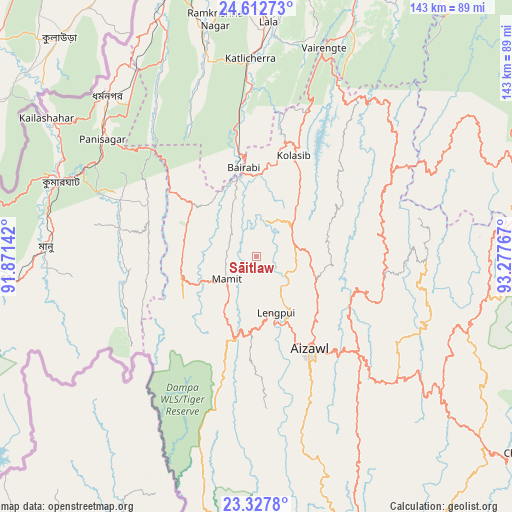
Sāitlaw GPS coordinates[2]
23° 58' 18.732" North, 92° 34' 28.344" East
| Map corner | latitude | longitude |
|---|---|---|
| Upper-left | 24.61273°, | 91.87142° |
| Center: | 23.97187°, | 92.57454° |
| Lower-right: | 23.3278°, | 93.27767° |
| Map W x H: | 142.9×142.9 km | = 88.8×88.8mi |
| max Lat: | 34.9274° ⇑41.9% North |
| Sāitlaw: | 23.97187° |
| min Lat: | ⇓58.1% South 8.09008° |
| min Long | Sāitlaw | max Long |
| 68.82655° | 92.57454° | 96.81° |
| W 97.3%⇐ | ⇒2.7% E |
Elevation
Elevation of Sāitlaw is 799 m = 2621 ft, and this is 503.4 m = 1652 ft above average elevation for this country.
| Max E: |
3681 m = 12077 ft | 6% |
| Sāitlaw | 799 m 2621 ft | |
| Avg. | 295.6 m = 970 ft | |
Min E: |
1 m = 3 ft | 94% |
See also: India elevation on elevation.city.
Geographical zone
Sāitlaw is located in North temperate zone (between Tropic of Cancer and the Arctic Circle). Distance of this Northern Tropic circle is 59.5 km =37 mi to South.| Distance of | km | miles | from Sāitlaw |
|---|---|---|---|
| North Pole | 7341.6 | 4561.9 | to North |
| Arctic Circle | 4735.8 | 2942.7 | to North |
| Tropic Cancer | 59.5 | 37 | to South |
| Equator | 2665.4 | 1656.2 | to South |


Nearby cities:
15 places around Sāitlaw: (largest is in red/bold)
• Aizawl
30.7 km =19.1 mi,  151°
151°
• Darlawn
35.8 km =22.2 mi,  82°
82°
• Dharmanagar
60.3 km =37.5 mi,  316°
316°
• Hailākāndi
79.2 km =49.2 mi,  359°
359°
• Kailāshahar
70.4 km =43.7 mi,  304°
304°
• Kamalpur
79.2 km =49.2 mi,  288°
288°
• Khawhai
86.8 km =53.9 mi,  139°
139°
• Kolasib
29.9 km =18.6 mi,  20°
20°
• Lāla
64.9 km =40.3 mi,  3°
3°
• Mamit
10 km =6.2 mi,  239°
239°
• Pherzawl
70.2 km =43.6 mi,  62°
62°
• Sairang
19.6 km =12.2 mi,  156°
156°
• Serchhīp
80.4 km =50 mi, 159°
• Thenzawl
75 km =46.6 mi,  166°
166°
• Āmbāsa
73.3 km =45.5 mi,  266°
266°
Sources, notices
• [Note1] Compared only with cities in India existing in our database
• [Src1] Map data: © OpenStreetMap contributors (CC-BY-SA)
• [Src2] Other city data from geonames.org with taken over terms of usage.
• [Src3] Geographical zone / Annual Mean Temperature by Robert A. Rohde @ Wikipedia
