Āmbāsa geodata
Āmbāsa (Tripura) is a populated place; located in India in Asia/Kolkata (GMT+5.5) time zone. With population of 6,373 people, there are 3263 cities with bigger population in this country. Compared to other cities in India, 57.9% of cities are located further ↓South; 96.8% of cities are located further ←West and 72.7% of cities have higher elevation than Āmbāsa. Note1


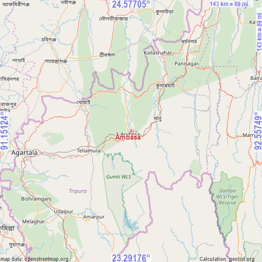
Āmbāsa GPS coordinates[2]
23° 56' 9.6" North, 91° 51' 15.696" East
| Map corner | latitude | longitude |
|---|---|---|
| Upper-left | 24.57705°, | 91.15124° |
| Center: | 23.936°, | 91.85436° |
| Lower-right: | 23.29176°, | 92.55749° |
| Map W x H: | 142.9×142.9 km | = 88.8×88.8mi |
| max Lat: | 34.9274° ⇑42.1% North |
| Āmbāsa: | 23.936° |
| min Lat: | ⇓57.9% South 8.09008° |
| min Long | Āmbāsa | max Long |
| 68.82655° | 91.85436° | 96.81° |
| W 96.8%⇐ | ⇒3.2% E |
Elevation
Elevation of Āmbāsa is 81 m = 266 ft, and this is 214.6 m = 704 ft below average elevation for this country.
| Max E: |
3681 m = 12077 ft | 72.7% |
| Avg. | 295.6 m = 970 ft | |
| Āmbāsa | 81 m = 266 ft | |
Min E: |
1 m = 3 ft | 27.3% |
See also: India elevation on elevation.city.
Geographical zone
Āmbāsa is located in North temperate zone (between Tropic of Cancer and the Arctic Circle). Distance of this Northern Tropic circle is 55.5 km =34.5 mi to South.| Distance of | km | miles | from Āmbāsa |
|---|---|---|---|
| North Pole | 7345.6 | 4564.3 | to North |
| Arctic Circle | 4739.7 | 2945.1 | to North |
| Tropic Cancer | 55.5 | 34.5 | to South |
| Equator | 2661.4 | 1653.7 | to South |


Nearby cities:
15 places around Āmbāsa: (largest is in red/bold)
• Agartala
59.5 km =37 mi,  259°
259°
• Amarpur
49.8 km =30.9 mi,  203°
203°
• Barjala
61.8 km =38.4 mi,  235°
235°
• Belonia
86.3 km =53.6 mi,  208°
208°
• Bishramganj
63.6 km =39.5 mi,  234°
234°
• Dharmanagar
57.4 km =35.7 mi,  33°
33°
• Kailāshahar
46.6 km =29 mi,  19°
19°
• Kamalpur
29 km =18 mi,  355°
355°
• Khowai
30.4 km =18.9 mi,  301°
301°
• Mamit
64.6 km =40.1 mi,  90°
90°
• Rānīr Bāzār
50.9 km =31.6 mi, 257°
• Sairang
82.3 km =51.1 mi,  99°
99°
• Sonāmura
78.8 km =49 mi, 229°
• Sāitlaw
73.3 km =45.5 mi, 86°
• Udaipur
58.6 km =36.4 mi,  220°
220°
Sources, notices
• [Note1] Compared only with cities in India existing in our database
• [Src1] Map data: © OpenStreetMap contributors (CC-BY-SA)
• [Src2] Other city data from geonames.org with taken over terms of usage.
• [Src3] Geographical zone / Annual Mean Temperature by Robert A. Rohde @ Wikipedia
