Amarpur geodata
Amarpur (Tripura) is a populated place; located in India in Asia/Kolkata (GMT+5.5) time zone. With population of 11,906 people, there are 2751 cities with bigger population in this country. Compared to other cities in India, 55% of cities are located further ↓South; 96.6% of cities are located further ←West and 81.7% of cities have higher elevation than Amarpur. Note1


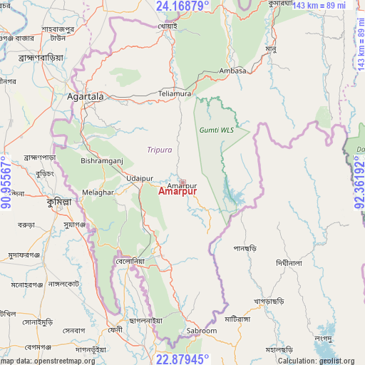
Amarpur GPS coordinates[2]
23° 31' 32.52" North, 91° 39' 31.644" East
| Map corner | latitude | longitude |
|---|---|---|
| Upper-left | 24.16879°, | 90.95567° |
| Center: | 23.5257°, | 91.65879° |
| Lower-right: | 22.87945°, | 92.36192° |
| Map W x H: | 143.4×143.4 km | = 89.1×89.1mi |
| max Lat: | 34.9274° ⇑45% North |
| Amarpur: | 23.5257° |
| min Lat: | ⇓55% South 8.09008° |
| min Long | Amarpur | max Long |
| 68.82655° | 91.65879° | 96.81° |
| W 96.6%⇐ | ⇒3.4% E |
Elevation
Elevation of Amarpur is 42 m = 138 ft, and this is 253.6 m = 832 ft below average elevation for this country.
| Max E: |
3681 m = 12077 ft | 81.7% |
| Avg. | 295.6 m = 970 ft | |
| Amarpur | 42 m = 138 ft | |
Min E: |
1 m = 3 ft | 18.3% |
See also: India elevation on elevation.city.
Geographical zone
Amarpur is located in North temperate zone (between Tropic of Cancer and the Arctic Circle). Distance of this Northern Tropic circle is 9.9 km =6.2 mi to South.| Distance of | km | miles | from Amarpur |
|---|---|---|---|
| North Pole | 7391.2 | 4592.7 | to North |
| Arctic Circle | 4785.4 | 2973.5 | to North |
| Tropic Cancer | 9.9 | 6.2 | to South |
| Equator | 2615.8 | 1625.4 | to South |


Nearby cities:
15 places around Amarpur: (largest is in red/bold)
• Agartala
51.8 km =32.2 mi,  311°
311°
• Barjala
32.5 km =20.2 mi,  288°
288°
• Belonia
36.9 km =22.9 mi,  214°
214°
• Bishramganj
33.3 km =20.7 mi, 285°
• Kailāshahar
96.3 km =59.8 mi,  21°
21°
• Kamalpur
76.6 km =47.6 mi,  13°
13°
• Khowai
61.9 km =38.5 mi,  354°
354°
• Mamit
95.6 km =59.4 mi,  62°
62°
• Rānīr Bāzār
45.5 km =28.3 mi,  319°
319°
• Sabrūm
58.7 km =36.5 mi,  173°
173°
• Sairang
106 km =65.9 mi,  72°
72°
• Sonāmura
40.4 km =25.1 mi,  262°
262°
• Sāitlaw
105.6 km =65.6 mi, 61°
• Udaipur
17.9 km =11.1 mi,  272°
272°
• Āmbāsa
49.8 km =30.9 mi, 23°
Sources, notices
• [Note1] Compared only with cities in India existing in our database
• [Src1] Map data: © OpenStreetMap contributors (CC-BY-SA)
• [Src2] Other city data from geonames.org with taken over terms of usage.
• [Src3] Geographical zone / Annual Mean Temperature by Robert A. Rohde @ Wikipedia
