Dharmanagar geodata
Dharmanagar (Tripura) is a populated place; located in India in Asia/Kolkata (GMT+5.5) time zone. With population of 32,912 people, there are 1323 cities with bigger population in this country. Compared to other cities in India, 59.8% of cities are located further ↓South; 97% of cities are located further ←West and 84.4% of cities have higher elevation than Dharmanagar. Note1


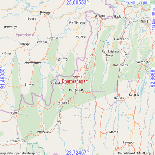
Dharmanagar GPS coordinates[2]
24° 22' 0.012" North, 92° 10' 0.012" East
| Map corner | latitude | longitude |
|---|---|---|
| Upper-left | 25.00553°, | 91.46355° |
| Center: | 24.36667°, | 92.16667° |
| Lower-right: | 23.72457°, | 92.8698° |
| Map W x H: | 142.4×142.4 km | = 88.5×88.5mi |
| max Lat: | 34.9274° ⇑40.2% North |
| Dharmanagar: | 24.36667° |
| min Lat: | ⇓59.8% South 8.09008° |
| min Long | Dharmanagar | max Long |
| 68.82655° | 92.16667° | 96.81° |
| W 97%⇐ | ⇒3% E |
Elevation
Elevation of Dharmanagar is 32 m = 105 ft, and this is 263.6 m = 865 ft below average elevation for this country.
| Max E: |
3681 m = 12077 ft | 84.4% |
| Avg. | 295.6 m = 970 ft | |
| Dharmanagar | 32 m = 105 ft | |
Min E: |
1 m = 3 ft | 15.6% |
See also: India elevation on elevation.city.
Geographical zone
Dharmanagar is located in North temperate zone (between Tropic of Cancer and the Arctic Circle). Distance of this Northern Tropic circle is 103.4 km =64.2 mi to South.| Distance of | km | miles | from Dharmanagar |
|---|---|---|---|
| North Pole | 7297.7 | 4534.6 | to North |
| Arctic Circle | 4691.9 | 2915.4 | to North |
| Tropic Cancer | 103.4 | 64.2 | to South |
| Equator | 2709.3 | 1683.5 | to South |


Nearby cities:
15 places around Dharmanagar: (largest is in red/bold)
• Aizawl
90.3 km =56.1 mi,  141°
141°
• Badarpur
70.7 km =43.9 mi,  37°
37°
• Darlawn
86.3 km =53.6 mi,  117°
117°
• Hailākāndi
53.2 km =33.1 mi,  48°
48°
• Kailāshahar
16.9 km =10.5 mi,  256°
256°
• Kamalpur
38.7 km =24 mi,  240°
240°
• Karīmganj
59 km =36.7 mi,  18°
18°
• Khowai
65.8 km =40.9 mi, 240°
• Kolasib
54.3 km =33.7 mi,  107°
107°
• Lāla
50 km =31.1 mi,  65°
65°
• Mamit
58.9 km =36.6 mi,  146°
146°
• Sairang
79.1 km =49.2 mi, 141°
• Silchar
81.8 km =50.8 mi, 51°
• Sāitlaw
60.3 km =37.5 mi, 136°
• Āmbāsa
57.4 km =35.7 mi,  213°
213°
Sources, notices
• [Note1] Compared only with cities in India existing in our database
• [Src1] Map data: © OpenStreetMap contributors (CC-BY-SA)
• [Src2] Other city data from geonames.org with taken over terms of usage.
• [Src3] Geographical zone / Annual Mean Temperature by Robert A. Rohde @ Wikipedia
