Udaipur geodata
Udaipur (Tripura) is a seat of a second-order administrative division; located in India in Asia/Kolkata (GMT+5.5) time zone. With population of 23,290 people, there are 1817 cities with bigger population in this country. Compared to other cities in India, 55% of cities are located further ↓South; 96.4% of cities are located further ←West and 85.8% of cities have higher elevation than Udaipur. Note1


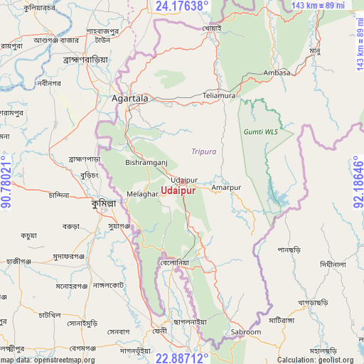
Udaipur GPS coordinates[2]
23° 31' 59.988" North, 91° 28' 59.988" East
| Map corner | latitude | longitude |
|---|---|---|
| Upper-left | 24.17638°, | 90.78021° |
| Center: | 23.53333°, | 91.48333° |
| Lower-right: | 22.88712°, | 92.18646° |
| Map W x H: | 143.4×143.4 km | = 89.1×89.1mi |
| max Lat: | 34.9274° ⇑45% North |
| Udaipur: | 23.53333° |
| min Lat: | ⇓55% South 8.09008° |
| min Long | Udaipur | max Long |
| 68.82655° | 91.48333° | 96.81° |
| W 96.4%⇐ | ⇒3.6% E |
Elevation
Elevation of Udaipur is 28 m = 92 ft, and this is 267.6 m = 878 ft below average elevation for this country.
| Max E: |
3681 m = 12077 ft | 85.8% |
| Avg. | 295.6 m = 970 ft | |
| Udaipur | 28 m = 92 ft | |
Min E: |
1 m = 3 ft | 14.2% |
See also: India elevation on elevation.city.
Geographical zone
Udaipur is located in North temperate zone (between Tropic of Cancer and the Arctic Circle). Distance of this Northern Tropic circle is 10.7 km =6.6 mi to South.| Distance of | km | miles | from Udaipur |
|---|---|---|---|
| North Pole | 7390.4 | 4592.2 | to North |
| Arctic Circle | 4784.5 | 2972.9 | to North |
| Tropic Cancer | 10.7 | 6.6 | to South |
| Equator | 2616.7 | 1625.9 | to South |


Nearby cities:
15 places around Udaipur: (largest is in red/bold)
• Agartala
39.5 km =24.5 mi,  328°
328°
• Amarpur
17.9 km =11.1 mi,  92°
92°
• Barjala
16 km =9.9 mi,  306°
306°
• Belonia
31.4 km =19.5 mi,  185°
185°
• Bishramganj
16.4 km =10.2 mi,  299°
299°
• Dharmanagar
115.8 km =72 mi,  36°
36°
• Kailāshahar
103.4 km =64.2 mi,  30°
30°
• Kamalpur
81.9 km =50.9 mi, 25°
• Khowai
61.9 km =38.5 mi,  11°
11°
• Mamit
111.4 km =69.2 mi,  66°
66°
• Rānīr Bāzār
35.6 km =22.1 mi,  340°
340°
• Sabrūm
64 km =39.8 mi,  157°
157°
• Sonāmura
23.1 km =14.4 mi,  253°
253°
• Sāitlaw
121.3 km =75.4 mi, 66°
• Āmbāsa
58.6 km =36.4 mi, 40°
Sources, notices
• [Note1] Compared only with cities in India existing in our database
• [Src1] Map data: © OpenStreetMap contributors (CC-BY-SA)
• [Src2] Other city data from geonames.org with taken over terms of usage.
• [Src3] Geographical zone / Annual Mean Temperature by Robert A. Rohde @ Wikipedia
