Sehore geodata
Sehore (Madhya Pradesh) is a populated place; located in India in Asia/Kolkata (GMT+5.5) time zone. With population of 99,284 people, there are 444 cities with bigger population in this country. Compared to other cities in India, 53% of cities are located further ↓South; 62.2% of cities are located further →East and 82.3% of cities have lower elevation than Sehore. Note1


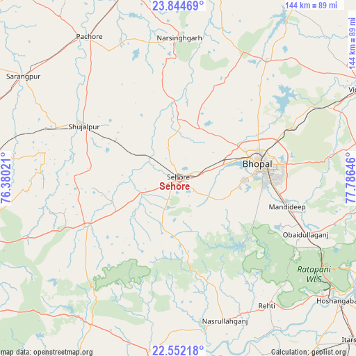
Sehore GPS coordinates[2]
23° 12' 0" North, 77° 4' 59.988" East
| Map corner | latitude | longitude |
|---|---|---|
| Upper-left | 23.84469°, | 76.38021° |
| Center: | 23.2°, | 77.08333° |
| Lower-right: | 22.55218°, | 77.78646° |
| Map W x H: | 143.7×143.7 km | = 89.3×89.3mi |
| max Lat: | 34.9274° ⇑47% North |
| Sehore: | 23.2° |
| min Lat: | ⇓53% South 8.09008° |
| min Long | Sehore | max Long |
| 68.82655° | 77.08333° | 96.81° |
| W 37.8%⇐ | ⇒62.2% E |
Elevation
Elevation of Sehore is 497 m = 1631 ft, and this is 201.4 m = 661 ft above average elevation for this country.
| Max E: |
3681 m = 12077 ft | 17.7% |
| Sehore | 497 m 1631 ft | |
| Avg. | 295.6 m = 970 ft | |
Min E: |
1 m = 3 ft | 82.3% |
See also: Sehore elevation on elevation.city.
Geographical zone
Sehore is located in North Torrid zone (between Equator and Tropic of Cancer). Distance of this Northern Tropic circle is 26.3 km =16.3 mi to North.| Distance of | km | miles | from Sehore |
|---|---|---|---|
| North Pole | 7427.5 | 4615.2 | to North |
| Arctic Circle | 4821.6 | 2996 | to North |
| Tropic Cancer | 26.3 | 16.3 | to North |
| Equator | 2579.6 | 1602.9 | to South |


Nearby cities:
15 places around Sehore: (largest is in red/bold)
• Akodia
53.4 km =33.2 mi,  292°
292°
• Ashta
42.1 km =26.2 mi,  241°
241°
• Berasia
59.8 km =37.2 mi,  36°
36°
• Bhopal
33.2 km =20.6 mi,  79°
79°
• Ichhāwar
20.3 km =12.6 mi,  199°
199°
• Iklehra
71.1 km =44.2 mi,  265°
265°
• Iāwar
63.2 km =39.3 mi,  250°
250°
• Kannod
68.7 km =42.7 mi,  210°
210°
• Khātegaon
69.4 km =43.1 mi,  194°
194°
• Mandideep
47.8 km =29.7 mi,  105°
105°
• Narsinghgarh
56.4 km =35 mi,  1°
1°
• Nasrullāhganj
60.5 km =37.6 mi,  161°
161°
• Rehti
62.7 km =39 mi,  145°
145°
• Shujālpur
44.5 km =27.7 mi,  301°
301°
• Talen
54.8 km =34.1 mi,  318°
318°
Sources, notices
• [Note1] Compared only with cities in India existing in our database
• [Src1] Map data: © OpenStreetMap contributors (CC-BY-SA)
• [Src2] Other city data from geonames.org with taken over terms of usage.
• [Src3] Geographical zone / Annual Mean Temperature by Robert A. Rohde @ Wikipedia
