Kargil geodata
Kargil (Jammu and Kashmir) is a populated place; located in India in Asia/Kolkata (GMT+5.5) time zone. With population of 13,838 people, there are 2579 cities with bigger population in this country. Compared to other cities in India, 100% of cities are located further ↓South; 72.4% of cities are located further →East and 99.8% of cities have lower elevation than Kargil. Note1


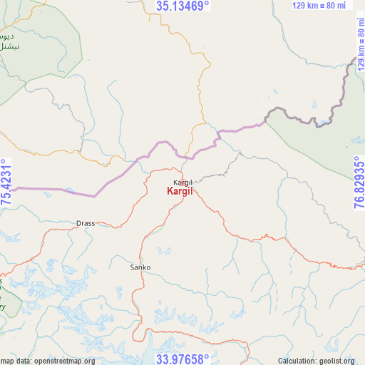
Kargil GPS coordinates[2]
34° 33' 27.54" North, 76° 7' 34.392" East
| Map corner | latitude | longitude |
|---|---|---|
| Upper-left | 35.13469°, | 75.4231° |
| Center: | 34.55765°, | 76.12622° |
| Lower-right: | 33.97658°, | 76.82935° |
| Map W x H: | 128.8×128.8 km | = 80×80mi |
| max Lat: | 34.9274° ⇑0% North |
| Kargil: | 34.55765° |
| min Lat: | ⇓100% South 8.09008° |
| min Long | Kargil | max Long |
| 68.82655° | 76.12622° | 96.81° |
| W 27.6%⇐ | ⇒72.4% E |
Elevation
Elevation of Kargil is 2686 m = 8812 ft, and this is 2390.4 m = 7843 ft above average elevation for this country.
| Max E: |
3681 m = 12077 ft | 0.2% |
| Kargil | 2686 m 8812 ft | |
| Avg. | 295.6 m = 970 ft | |
Min E: |
1 m = 3 ft | 99.8% |
See also: India elevation on elevation.city.
Geographical zone
Kargil is located in North temperate zone (between Tropic of Cancer and the Arctic Circle). Distance of this Northern Tropic circle is 1236.5 km =768.3 mi to South.| Distance of | km | miles | from Kargil |
|---|---|---|---|
| North Pole | 6164.6 | 3830.5 | to North |
| Arctic Circle | 3558.7 | 2211.3 | to North |
| Tropic Cancer | 1236.5 | 768.3 | to South |
| Equator | 3842.5 | 2387.6 | to South |


Nearby cities:
15 places around Kargil: (largest is in red/bold)
• Anantnag
128.3 km =79.7 mi,  224°
224°
• Awantipur
124.3 km =77.2 mi,  235°
235°
• Bandipura
136.8 km =85 mi,  263°
263°
• Bijbehara
126.5 km =78.6 mi,  227°
227°
• Gāndarbal
129.4 km =80.4 mi,  253°
253°
• Leh
140.7 km =87.4 mi,  108°
108°
• Padam
140 km =87 mi,  150°
150°
• Pahlgām
95.5 km =59.3 mi, 230°
• Pulwama
136 km =84.5 mi, 236°
• Qāzigund
136.6 km =84.9 mi, 221°
• Soyībug
141 km =87.6 mi, 247°
• Srinagar
132.1 km =82.1 mi, 246°
• Sumbal
140.5 km =87.3 mi, 255°
• Thang
73.5 km =45.7 mi,  56°
56°
• Trāl
116.4 km =72.3 mi, 232°
Sources, notices
• [Note1] Compared only with cities in India existing in our database
• [Src1] Map data: © OpenStreetMap contributors (CC-BY-SA)
• [Src2] Other city data from geonames.org with taken over terms of usage.
• [Src3] Geographical zone / Annual Mean Temperature by Robert A. Rohde @ Wikipedia
