Leh geodata
Leh (Jammu and Kashmir) is a populated place; located in India in Asia/Kolkata (GMT+5.5) time zone. With population of 37,475 people, there are 1176 cities with bigger population in this country. Compared to other cities in India, 99.8% of cities are located further ↓South; 56.3% of cities are located further →East and 99.9% of cities have lower elevation than Leh. Note1


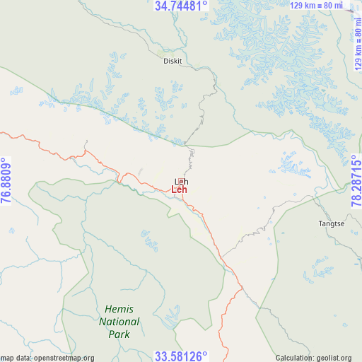
Leh GPS coordinates[2]
34° 9' 54.144" North, 77° 35' 2.472" East
| Map corner | latitude | longitude |
|---|---|---|
| Upper-left | 34.74481°, | 76.8809° |
| Center: | 34.16504°, | 77.58402° |
| Lower-right: | 33.58126°, | 78.28715° |
| Map W x H: | 129.4×129.4 km | = 80.4×80.4mi |
| max Lat: | 34.9274° ⇑0.2% North |
| Leh: | 34.16504° |
| min Lat: | ⇓99.8% South 8.09008° |
| min Long | Leh | max Long |
| 68.82655° | 77.58402° | 96.81° |
| W 43.7%⇐ | ⇒56.3% E |
Elevation
Elevation of Leh is 3502 m = 11490 ft, and this is 3206.4 m = 10520 ft above average elevation for this country.
| Max E: |
3681 m = 12077 ft | 0.099999999999994% |
| Leh | 3502 m 11490 ft | |
| Avg. | 295.6 m = 970 ft | |
Min E: |
1 m = 3 ft | 99.9% |
See also: India elevation on elevation.city.
Geographical zone
Leh is located in North temperate zone (between Tropic of Cancer and the Arctic Circle). Distance of this Northern Tropic circle is 1192.9 km =741.2 mi to South.| Distance of | km | miles | from Leh |
|---|---|---|---|
| North Pole | 6208.3 | 3857.7 | to North |
| Arctic Circle | 3602.4 | 2238.4 | to North |
| Tropic Cancer | 1192.9 | 741.2 | to South |
| Equator | 3798.8 | 2360.5 | to South |


Nearby cities:
15 places around Leh: (largest is in red/bold)
• Anantnag
229.3 km =142.5 mi,  257°
257°
• Bhadarwāh
217.5 km =135.1 mi,  232°
232°
• Bijbehara
232.1 km =144.2 mi, 259°
• Chamba
224.4 km =139.4 mi,  217°
217°
• Doda
219.7 km =136.5 mi,  239°
239°
• Kargil
140.7 km =87.4 mi,  288°
288°
• Kishtwār
192.8 km =119.8 mi, 240°
• Kyelang
184.6 km =114.7 mi,  196°
196°
• Manāli
215.5 km =133.9 mi,  190°
190°
• Nagar
228.6 km =142 mi, 189°
• Padam
101 km =62.8 mi, 219°
• Pahlgām
209.2 km =130 mi,  265°
265°
• Qāzigund
232.8 km =144.7 mi, 255°
• Thang
111.5 km =69.3 mi,  319°
319°
• Trāl
228.9 km =142.2 mi, 263°
Sources, notices
• [Note1] Compared only with cities in India existing in our database
• [Src1] Map data: © OpenStreetMap contributors (CC-BY-SA)
• [Src2] Other city data from geonames.org with taken over terms of usage.
• [Src3] Geographical zone / Annual Mean Temperature by Robert A. Rohde @ Wikipedia
