Tāndā geodata
Tāndā (Uttar Pradesh) is a populated place; located in India in Asia/Kolkata (GMT+5.5) time zone. With population of 88,073 people, there are 508 cities with bigger population in this country. Compared to other cities in India, 75% of cities are located further ↓South; 78.4% of cities are located further ←West and 69.4% of cities have higher elevation than Tāndā. Note1


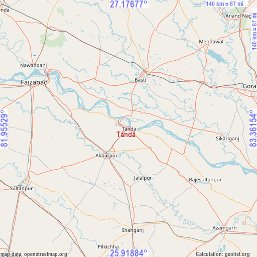
Tāndā GPS coordinates[2]
26° 32' 58.308" North, 82° 39' 30.276" East
| Map corner | latitude | longitude |
|---|---|---|
| Upper-left | 27.17677°, | 81.95529° |
| Center: | 26.54953°, | 82.65841° |
| Lower-right: | 25.91884°, | 83.36154° |
| Map W x H: | 139.9×139.9 km | = 86.9×86.9mi |
| max Lat: | 34.9274° ⇑25% North |
| Tāndā: | 26.54953° |
| min Lat: | ⇓75% South 8.09008° |
| min Long | Tāndā | max Long |
| 68.82655° | 82.65841° | 96.81° |
| W 78.4%⇐ | ⇒21.6% E |
Elevation
Elevation of Tāndā is 95 m = 312 ft, and this is 200.6 m = 658 ft below average elevation for this country.
| Max E: |
3681 m = 12077 ft | 69.4% |
| Avg. | 295.6 m = 970 ft | |
| Tāndā | 95 m = 312 ft | |
Min E: |
1 m = 3 ft | 30.6% |
See also: Tāndā elevation on elevation.city.
Geographical zone
Tāndā is located in North temperate zone (between Tropic of Cancer and the Arctic Circle). Distance of this Northern Tropic circle is 346.1 km =215.1 mi to South.| Distance of | km | miles | from Tāndā |
|---|---|---|---|
| North Pole | 7055 | 4383.8 | to North |
| Arctic Circle | 4449.1 | 2764.5 | to North |
| Tropic Cancer | 346.1 | 215.1 | to South |
| Equator | 2952 | 1834.3 | to South |


Nearby cities:
15 places around Tāndā: (largest is in red/bold)
• Ajodhya
52.9 km =32.9 mi,  301°
301°
• Akbarpur
18.2 km =11.3 mi,  222°
222°
• Atraulia
37.5 km =23.3 mi,  129°
129°
• Bastī
27.1 km =16.8 mi,  12°
12°
• Bishunpur Urf Mahārājganj
55.9 km =34.7 mi, 125°
• Bīkāpur
52.5 km =32.6 mi,  275°
275°
• Dostpur
35.8 km =22.2 mi,  211°
211°
• Fyzābād
56.4 km =35 mi, 296°
• Goshāinganj
27.7 km =17.2 mi,  274°
274°
• Haraiya
33.4 km =20.8 mi,  324°
324°
• Jalālpur
27.6 km =17.1 mi,  163°
163°
• Khalīlābād
48 km =29.8 mi,  58°
58°
• Kādīpur
51.2 km =31.8 mi, 214°
• Maghar
52 km =32.3 mi, 63°
• Shāhganj
55.6 km =34.5 mi,  177°
177°
Sources, notices
• [Note1] Compared only with cities in India existing in our database
• [Src1] Map data: © OpenStreetMap contributors (CC-BY-SA)
• [Src2] Other city data from geonames.org with taken over terms of usage.
• [Src3] Geographical zone / Annual Mean Temperature by Robert A. Rohde @ Wikipedia
