Haraiya geodata
Haraiya (Uttar Pradesh) is a populated place; located in India in Asia/Kolkata (GMT+5.5) time zone. With population of 9,000 people, there are 3034 cities with bigger population in this country. Compared to other cities in India, 76.8% of cities are located further ↓South; 77.8% of cities are located further ←West and 69.7% of cities have higher elevation than Haraiya. Note1


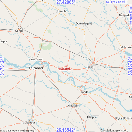
Haraiya GPS coordinates[2]
26° 47' 41.172" North, 82° 27' 51.696" East
| Map corner | latitude | longitude |
|---|---|---|
| Upper-left | 27.42065°, | 81.76124° |
| Center: | 26.79477°, | 82.46436° |
| Lower-right: | 26.16542°, | 83.16749° |
| Map W x H: | 139.6×139.6 km | = 86.7×86.7mi |
| max Lat: | 34.9274° ⇑23.2% North |
| Haraiya: | 26.79477° |
| min Lat: | ⇓76.8% South 8.09008° |
| min Long | Haraiya | max Long |
| 68.82655° | 82.46436° | 96.81° |
| W 77.8%⇐ | ⇒22.2% E |
Elevation
Elevation of Haraiya is 94 m = 308 ft, and this is 201.6 m = 661 ft below average elevation for this country.
| Max E: |
3681 m = 12077 ft | 69.7% |
| Avg. | 295.6 m = 970 ft | |
| Haraiya | 94 m = 308 ft | |
Min E: |
1 m = 3 ft | 30.3% |
See also: India elevation on elevation.city.
Geographical zone
Haraiya is located in North temperate zone (between Tropic of Cancer and the Arctic Circle). Distance of this Northern Tropic circle is 373.4 km =232 mi to South.| Distance of | km | miles | from Haraiya |
|---|---|---|---|
| North Pole | 7027.8 | 4366.9 | to North |
| Arctic Circle | 4421.9 | 2747.6 | to North |
| Tropic Cancer | 373.4 | 232 | to South |
| Equator | 2979.3 | 1851.3 | to South |


Nearby cities:
15 places around Haraiya: (largest is in red/bold)
• Ajodhya
25.8 km =16 mi,  271°
271°
• Akbarpur
41.2 km =25.6 mi,  170°
170°
• Bastī
25 km =15.5 mi,  91°
91°
• Bānsi
63.1 km =39.2 mi,  47°
47°
• Bīkāpur
39.7 km =24.7 mi,  236°
236°
• Dostpur
57.8 km =35.9 mi,  179°
179°
• Fyzābād
31.3 km =19.4 mi, 266°
• Gondā City
63 km =39.1 mi,  306°
306°
• Goshāinganj
26.2 km =16.3 mi,  198°
198°
• Jalālpur
60.2 km =37.4 mi,  153°
153°
• Khalīlābād
60.3 km =37.5 mi, 92°
• Mankāpur
36.9 km =22.9 mi,  320°
320°
• Nawābganj
33 km =20.5 mi,  283°
283°
• Tāndā
33.4 km =20.8 mi,  144°
144°
• Utraula
58.5 km =36.4 mi,  355°
355°
Sources, notices
• [Note1] Compared only with cities in India existing in our database
• [Src1] Map data: © OpenStreetMap contributors (CC-BY-SA)
• [Src2] Other city data from geonames.org with taken over terms of usage.
• [Src3] Geographical zone / Annual Mean Temperature by Robert A. Rohde @ Wikipedia
