Akbarpur geodata
Akbarpur (Uttar Pradesh) is a populated place; located in India in Asia/Kolkata (GMT+5.5) time zone. With population of 36,865 people, there are 1192 cities with bigger population in this country. Compared to other cities in India, 73.9% of cities are located further ↓South; 77.9% of cities are located further ←West and 70.8% of cities have higher elevation than Akbarpur. Note1


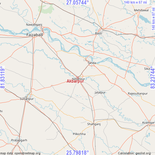
Akbarpur GPS coordinates[2]
26° 25' 46.308" North, 82° 32' 3.516" East
| Map corner | latitude | longitude |
|---|---|---|
| Upper-left | 27.05744°, | 81.83119° |
| Center: | 26.42953°, | 82.53431° |
| Lower-right: | 25.79818°, | 83.23744° |
| Map W x H: | 140×140 km | = 87×87mi |
| max Lat: | 34.9274° ⇑26.1% North |
| Akbarpur: | 26.42953° |
| min Lat: | ⇓73.9% South 8.09008° |
| min Long | Akbarpur | max Long |
| 68.82655° | 82.53431° | 96.81° |
| W 77.9%⇐ | ⇒22.1% E |
Elevation
Elevation of Akbarpur is 89 m = 292 ft, and this is 206.6 m = 678 ft below average elevation for this country.
| Max E: |
3681 m = 12077 ft | 70.8% |
| Avg. | 295.6 m = 970 ft | |
| Akbarpur | 89 m = 292 ft | |
Min E: |
1 m = 3 ft | 29.2% |
See also: India elevation on elevation.city.
Geographical zone
Akbarpur is located in North temperate zone (between Tropic of Cancer and the Arctic Circle). Distance of this Northern Tropic circle is 332.8 km =206.8 mi to South.| Distance of | km | miles | from Akbarpur |
|---|---|---|---|
| North Pole | 7068.4 | 4392.1 | to North |
| Arctic Circle | 4462.5 | 2772.9 | to North |
| Tropic Cancer | 332.8 | 206.8 | to South |
| Equator | 2938.7 | 1826 | to South |


Nearby cities:
15 places around Akbarpur: (largest is in red/bold)
• Ajodhya
52.6 km =32.7 mi,  321°
321°
• Atraulia
42.5 km =26.4 mi,  104°
104°
• Bastī
43.8 km =27.2 mi,  24°
24°
• Bīkāpur
44 km =27.3 mi,  294°
294°
• Dostpur
18.3 km =11.4 mi,  200°
200°
• Fyzābād
54.2 km =33.7 mi, 315°
• Goshāinganj
21.9 km =13.6 mi, 315°
• Haraiya
41.2 km =25.6 mi,  350°
350°
• Jalālpur
24.2 km =15 mi,  122°
122°
• Kādīpur
33.4 km =20.8 mi,  209°
209°
• Phūlpur
51.9 km =32.2 mi,  138°
138°
• Sarāi Mīr
58.9 km =36.6 mi, 139°
• Shāhganj
44.8 km =27.8 mi,  160°
160°
• Sultānpur
49.8 km =30.9 mi,  247°
247°
• Tāndā
18.2 km =11.3 mi,  42°
42°
Sources, notices
• [Note1] Compared only with cities in India existing in our database
• [Src1] Map data: © OpenStreetMap contributors (CC-BY-SA)
• [Src2] Other city data from geonames.org with taken over terms of usage.
• [Src3] Geographical zone / Annual Mean Temperature by Robert A. Rohde @ Wikipedia
