Dostpur geodata
Dostpur (Uttar Pradesh) is a populated place; located in India in Asia/Kolkata (GMT+5.5) time zone. With population of 12,688 people, there are 2682 cities with bigger population in this country. Compared to other cities in India, 72.8% of cities are located further ↓South; 77.8% of cities are located further ←West and 69.1% of cities have higher elevation than Dostpur. Note1


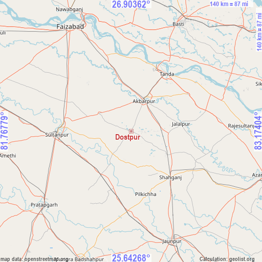
Dostpur GPS coordinates[2]
26° 16' 29.496" North, 82° 28' 15.276" East
| Map corner | latitude | longitude |
|---|---|---|
| Upper-left | 26.90362°, | 81.76779° |
| Center: | 26.27486°, | 82.47091° |
| Lower-right: | 25.64268°, | 83.17404° |
| Map W x H: | 140.2×140.2 km | = 87.1×87.1mi |
| max Lat: | 34.9274° ⇑27.2% North |
| Dostpur: | 26.27486° |
| min Lat: | ⇓72.8% South 8.09008° |
| min Long | Dostpur | max Long |
| 68.82655° | 82.47091° | 96.81° |
| W 77.8%⇐ | ⇒22.2% E |
Elevation
Elevation of Dostpur is 97 m = 318 ft, and this is 198.6 m = 652 ft below average elevation for this country.
| Max E: |
3681 m = 12077 ft | 69.1% |
| Avg. | 295.6 m = 970 ft | |
| Dostpur | 97 m = 318 ft | |
Min E: |
1 m = 3 ft | 30.9% |
See also: India elevation on elevation.city.
Geographical zone
Dostpur is located in North temperate zone (between Tropic of Cancer and the Arctic Circle). Distance of this Northern Tropic circle is 315.6 km =196.1 mi to South.| Distance of | km | miles | from Dostpur |
|---|---|---|---|
| North Pole | 7085.6 | 4402.8 | to North |
| Arctic Circle | 4479.7 | 2783.6 | to North |
| Tropic Cancer | 315.6 | 196.1 | to South |
| Equator | 2921.5 | 1815.3 | to South |


Nearby cities:
15 places around Dostpur: (largest is in red/bold)
• Akbarpur
18.3 km =11.4 mi,  20°
20°
• Antu
61.7 km =38.3 mi,  246°
246°
• Atraulia
47.9 km =29.8 mi,  82°
82°
• Bela
61.6 km =38.3 mi,  230°
230°
• Bīkāpur
49 km =30.4 mi,  316°
316°
• Goshāinganj
34.1 km =21.2 mi,  344°
344°
• Haraiya
57.8 km =35.9 mi,  359°
359°
• Jalālpur
27 km =16.8 mi, 81°
• Kādīpur
15.6 km =9.7 mi,  220°
220°
• Patti
47.7 km =29.6 mi,  214°
214°
• Phūlpur
46 km =28.6 mi,  118°
118°
• Sarāi Mīr
52.5 km =32.6 mi, 121°
• Shāhganj
32.9 km =20.4 mi,  139°
139°
• Sultānpur
39.8 km =24.7 mi,  267°
267°
• Tāndā
35.8 km =22.2 mi,  31°
31°
Sources, notices
• [Note1] Compared only with cities in India existing in our database
• [Src1] Map data: © OpenStreetMap contributors (CC-BY-SA)
• [Src2] Other city data from geonames.org with taken over terms of usage.
• [Src3] Geographical zone / Annual Mean Temperature by Robert A. Rohde @ Wikipedia
