Bāgha Purāna geodata
Bāgha Purāna (Punjab) is a populated place; located in India in Asia/Kolkata (GMT+5.5) time zone. With population of 23,360 people, there are 1813 cities with bigger population in this country. Compared to other cities in India, 94.8% of cities are located further ↓South; 81.9% of cities are located further →East and 54% of cities have lower elevation than Bāgha Purāna. Note1


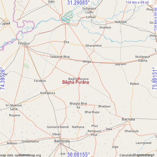
Bāgha Purāna GPS coordinates[2]
30° 41' 17.124" North, 75° 5' 54.168" East
| Map corner | latitude | longitude |
|---|---|---|
| Upper-left | 31.29085°, | 74.39526° |
| Center: | 30.68809°, | 75.09838° |
| Lower-right: | 30.08155°, | 75.80151° |
| Map W x H: | 134.5×134.5 km | = 83.6×83.6mi |
| max Lat: | 34.9274° ⇑5.2% North |
| Bāgha Purāna: | 30.68809° |
| min Lat: | ⇓94.8% South 8.09008° |
| min Long | Bāgha Purāna | max Long |
| 68.82655° | 75.09838° | 96.81° |
| W 18.1%⇐ | ⇒81.9% E |
Elevation
Elevation of Bāgha Purāna is 222 m = 728 ft, and this is 73.6 m = 241 ft below average elevation for this country.
| Max E: |
3681 m = 12077 ft | 46% |
| Avg. | 295.6 m = 970 ft | |
| Bāgha Purāna | 222 m = 728 ft | |
Min E: |
1 m = 3 ft | 54% |
See also: India elevation on elevation.city.
Geographical zone
Bāgha Purāna is located in North temperate zone (between Tropic of Cancer and the Arctic Circle). Distance of this Northern Tropic circle is 806.3 km =501 mi to South.| Distance of | km | miles | from Bāgha Purāna |
|---|---|---|---|
| North Pole | 6594.9 | 4097.9 | to North |
| Arctic Circle | 3989 | 2478.6 | to North |
| Tropic Cancer | 806.3 | 501 | to South |
| Equator | 3412.2 | 2120.2 | to South |


Nearby cities:
15 places around Bāgha Purāna: (largest is in red/bold)
• Badhni Kalān
18.4 km =11.4 mi,  92°
92°
• Bhadaur
32.4 km =20.1 mi,  136°
136°
• Farīdkot
32.8 km =20.4 mi,  267°
267°
• Ferozepore
53.3 km =33.1 mi,  299°
299°
• Jagraon
37.6 km =23.4 mi,  72°
72°
• Jaito
32.9 km =20.4 mi,  216°
216°
• Kot Īsa Khān
29 km =18 mi,  7°
7°
• Kotkapura
28 km =17.4 mi,  245°
245°
• Makhu
47.2 km =29.3 mi,  348°
348°
• Moga
15.5 km =9.6 mi,  25°
25°
• Rāikot
48.2 km =30 mi,  95°
95°
• Rāmpura
50 km =31.1 mi,  164°
164°
• Shāhkot
49.3 km =30.6 mi, 27°
• Talwandi Bhai
24.6 km =15.3 mi,  319°
319°
• Zira
32.8 km =20.4 mi,  341°
341°
Sources, notices
• [Note1] Compared only with cities in India existing in our database
• [Src1] Map data: © OpenStreetMap contributors (CC-BY-SA)
• [Src2] Other city data from geonames.org with taken over terms of usage.
• [Src3] Geographical zone / Annual Mean Temperature by Robert A. Rohde @ Wikipedia
