Bangarapet geodata
Bangarapet (Karnataka) is a populated place; located in India in Asia/Kolkata (GMT+5.5) time zone. With population of 42,789 people, there are 1031 cities with bigger population in this country. Compared to other cities in India, 86.4% of cities are located further ↑North; 50.9% of cities are located further ←West and 94.3% of cities have lower elevation than Bangarapet. Note1


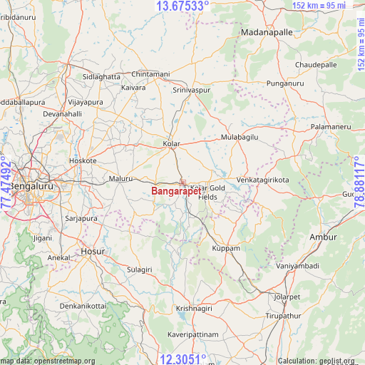
Bangarapet GPS coordinates[2]
12° 59' 28.176" North, 78° 10' 40.944" East
| Map corner | latitude | longitude |
|---|---|---|
| Upper-left | 13.67533°, | 77.47492° |
| Center: | 12.99116°, | 78.17804° |
| Lower-right: | 12.3051°, | 78.88117° |
| Map W x H: | 152.4×152.4 km | = 94.7×94.7mi |
| max Lat: | 34.9274° ⇑86.4% North |
| Bangarapet: | 12.99116° |
| min Lat: | ⇓13.6% South 8.09008° |
| min Long | Bangarapet | max Long |
| 68.82655° | 78.17804° | 96.81° |
| W 50.9%⇐ | ⇒49.1% E |
Elevation
Elevation of Bangarapet is 826 m = 2710 ft, and this is 530.4 m = 1740 ft above average elevation for this country.
| Max E: |
3681 m = 12077 ft | 5.7% |
| Bangarapet | 826 m 2710 ft | |
| Avg. | 295.6 m = 970 ft | |
Min E: |
1 m = 3 ft | 94.3% |
See also: Bangarapet elevation on elevation.city.
Geographical zone
Bangarapet is located in North Torrid zone (between Equator and Tropic of Cancer). Distance of this Northern Tropic circle is 1161.4 km =721.7 mi to North.| Distance of | km | miles | from Bangarapet |
|---|---|---|---|
| North Pole | 8562.6 | 5320.6 | to North |
| Arctic Circle | 5956.7 | 3701.3 | to North |
| Tropic Cancer | 1161.4 | 721.7 | to North |
| Equator | 1444.5 | 897.6 | to South |


Nearby cities:
15 places around Bangarapet: (largest is in red/bold)
• Chintāmani
47.5 km =29.5 mi,  343°
343°
• Dasarahalli
39.4 km =24.5 mi,  287°
287°
• Devanhalli
57.9 km =36 mi,  299°
299°
• Hoskote
42.1 km =26.2 mi,  282°
282°
• Hosūr
46.9 km =29.1 mi,  232°
232°
• Kelamangalam
55.8 km =34.7 mi,  219°
219°
• Kolār
17.1 km =10.6 mi, 342°
• Krishnagiri
52.6 km =32.7 mi,  175°
175°
• Kuppam
32.2 km =20 mi,  146°
146°
• Mulbāgal
30.2 km =18.8 mi,  50°
50°
• Mālūr
26 km =16.2 mi,  272°
272°
• Robertsonpet
11.2 km =7 mi,  110°
110°
• Sidlaghatta
55.8 km =34.7 mi,  322°
322°
• Srīnivāspur
38.9 km =24.2 mi,  5°
5°
• Vadigenhalli
53.1 km =33 mi,  309°
309°
Sources, notices
• [Note1] Compared only with cities in India existing in our database
• [Src1] Map data: © OpenStreetMap contributors (CC-BY-SA)
• [Src2] Other city data from geonames.org with taken over terms of usage.
• [Src3] Geographical zone / Annual Mean Temperature by Robert A. Rohde @ Wikipedia
