Maibong geodata
Maibong (Assam) is a populated place; located in India in Asia/Kolkata (GMT+5.5) time zone. With population of 8,364 people, there are 3091 cities with bigger population in this country. Compared to other cities in India, 65.2% of cities are located further ↓South; 98% of cities are located further ←West and 66.2% of cities have lower elevation than Maibong. Note1


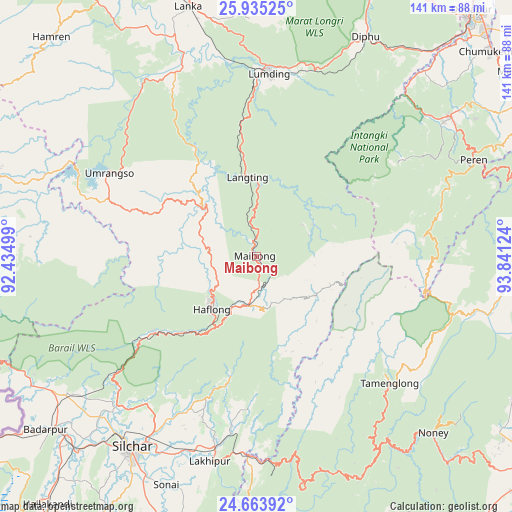
Maibong GPS coordinates[2]
25° 18' 4.5" North, 93° 8' 17.196" East
| Map corner | latitude | longitude |
|---|---|---|
| Upper-left | 25.93525°, | 92.43499° |
| Center: | 25.30125°, | 93.13811° |
| Lower-right: | 24.66392°, | 93.84124° |
| Map W x H: | 141.4×141.4 km | = 87.9×87.9mi |
| max Lat: | 34.9274° ⇑34.8% North |
| Maibong: | 25.30125° |
| min Lat: | ⇓65.2% South 8.09008° |
| min Long | Maibong | max Long |
| 68.82655° | 93.13811° | 96.81° |
| W 98%⇐ | ⇒2% E |
Elevation
Elevation of Maibong is 295 m = 968 ft, and this is 0.60000000000002 m = 2 ft below average elevation for this country.
| Max E: |
3681 m = 12077 ft | 33.8% |
| Avg. | 295.6 m = 970 ft | |
| Maibong | 295 m = 968 ft | |
Min E: |
1 m = 3 ft | 66.2% |
See also: India elevation on elevation.city.
Geographical zone
Maibong is located in North temperate zone (between Tropic of Cancer and the Arctic Circle). Distance of this Northern Tropic circle is 207.3 km =128.8 mi to South.| Distance of | km | miles | from Maibong |
|---|---|---|---|
| North Pole | 7193.8 | 4470 | to North |
| Arctic Circle | 4587.9 | 2850.8 | to North |
| Tropic Cancer | 207.3 | 128.8 | to South |
| Equator | 2813.2 | 1748 | to South |


Nearby cities:
15 places around Maibong: (largest is in red/bold)
• Badarpur
72.8 km =45.2 mi,  228°
228°
• Dimāpur
89.6 km =55.7 mi,  40°
40°
• Diphu
67.1 km =41.7 mi,  25°
25°
• Hailākāndi
90 km =55.9 mi,  220°
220°
• Hamren
87.6 km =54.4 mi,  323°
323°
• Hojāi
83 km =51.6 mi,  340°
340°
• Hāflong
19.4 km =12.1 mi, 218°
• Jiribam
55.3 km =34.4 mi,  181°
181°
• Karīmganj
92.3 km =57.4 mi,  238°
238°
• Khliehriat
77.8 km =48.3 mi,  274°
274°
• Kāngpokpi
85.5 km =53.1 mi,  101°
101°
• Lakhipur
58 km =36 mi,  192°
192°
• Lumding Railway Colony
49.9 km =31 mi,  3°
3°
• Mahur
13.4 km =8.3 mi, 190°
• Silchar
62.9 km =39.1 mi,  213°
213°
Sources, notices
• [Note1] Compared only with cities in India existing in our database
• [Src1] Map data: © OpenStreetMap contributors (CC-BY-SA)
• [Src2] Other city data from geonames.org with taken over terms of usage.
• [Src3] Geographical zone / Annual Mean Temperature by Robert A. Rohde @ Wikipedia
