Hāflong geodata
Hāflong (Assam) is a populated place; located in India in Asia/Kolkata (GMT+5.5) time zone. With population of 39,982 people, there are 1106 cities with bigger population in this country. Compared to other cities in India, 64.2% of cities are located further ↓South; 97.9% of cities are located further ←West and 92% of cities have lower elevation than Hāflong. Note1


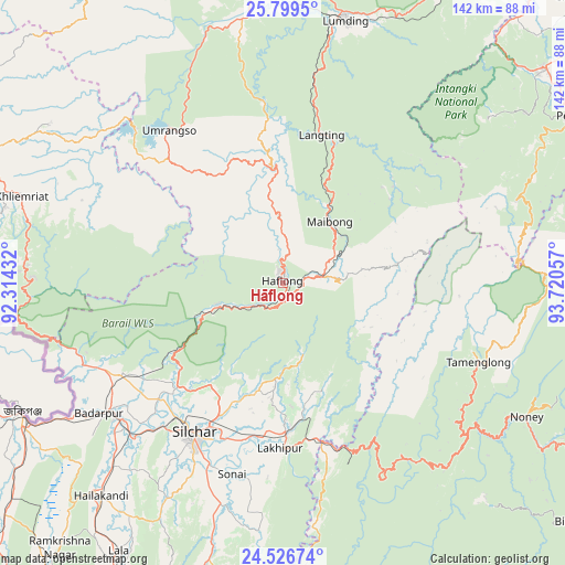
Hāflong GPS coordinates[2]
25° 9' 53.208" North, 93° 1' 2.784" East
| Map corner | latitude | longitude |
|---|---|---|
| Upper-left | 25.7995°, | 92.31432° |
| Center: | 25.16478°, | 93.01744° |
| Lower-right: | 24.52674°, | 93.72057° |
| Map W x H: | 141.5×141.5 km | = 87.9×87.9mi |
| max Lat: | 34.9274° ⇑35.8% North |
| Hāflong: | 25.16478° |
| min Lat: | ⇓64.2% South 8.09008° |
| min Long | Hāflong | max Long |
| 68.82655° | 93.01744° | 96.81° |
| W 97.9%⇐ | ⇒2.1% E |
Elevation
Elevation of Hāflong is 684 m = 2244 ft, and this is 388.4 m = 1274 ft above average elevation for this country.
| Max E: |
3681 m = 12077 ft | 8% |
| Hāflong | 684 m 2244 ft | |
| Avg. | 295.6 m = 970 ft | |
Min E: |
1 m = 3 ft | 92% |
See also: India elevation on elevation.city.
Geographical zone
Hāflong is located in North temperate zone (between Tropic of Cancer and the Arctic Circle). Distance of this Northern Tropic circle is 192.1 km =119.4 mi to South.| Distance of | km | miles | from Hāflong |
|---|---|---|---|
| North Pole | 7209 | 4479.5 | to North |
| Arctic Circle | 4603.1 | 2860.2 | to North |
| Tropic Cancer | 192.1 | 119.4 | to South |
| Equator | 2798.1 | 1738.7 | to South |


Nearby cities:
15 places around Hāflong: (largest is in red/bold)
• Badarpur
53.7 km =33.4 mi,  232°
232°
• Bishnupur
95.9 km =59.6 mi,  128°
128°
• Diphu
86.1 km =53.5 mi,  28°
28°
• Hailākāndi
70.5 km =43.8 mi,  220°
220°
• Hamren
94.5 km =58.7 mi,  334°
334°
• Hojāi
94.6 km =58.8 mi,  350°
350°
• Jiribam
41.4 km =25.7 mi,  165°
165°
• Karīmganj
74.4 km =46.2 mi,  243°
243°
• Khliehriat
68.9 km =42.8 mi,  288°
288°
• Lakhipur
41.4 km =25.7 mi,  181°
181°
• Lumding Railway Colony
66.7 km =41.4 mi,  13°
13°
• Lāla
79.1 km =49.2 mi,  210°
210°
• Mahur
9.9 km =6.2 mi,  78°
78°
• Maibong
19.4 km =12.1 mi,  38°
38°
• Silchar
43.6 km =27.1 mi, 210°
Sources, notices
• [Note1] Compared only with cities in India existing in our database
• [Src1] Map data: © OpenStreetMap contributors (CC-BY-SA)
• [Src2] Other city data from geonames.org with taken over terms of usage.
• [Src3] Geographical zone / Annual Mean Temperature by Robert A. Rohde @ Wikipedia
