Diphu geodata
Diphu (Assam) is a populated place; located in India in Asia/Kolkata (GMT+5.5) time zone. With population of 57,097 people, there are 774 cities with bigger population in this country. Compared to other cities in India, 69.2% of cities are located further ↓South; 98.1% of cities are located further ←West and 50.2% of cities have higher elevation than Diphu. Note1


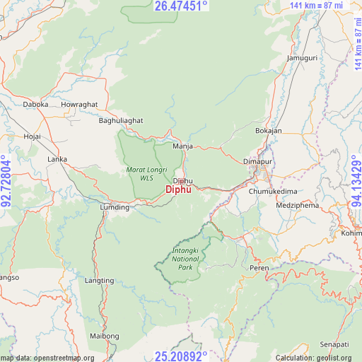
Diphu GPS coordinates[2]
25° 50' 36.276" North, 93° 25' 52.176" East
| Map corner | latitude | longitude |
|---|---|---|
| Upper-left | 26.47451°, | 92.72804° |
| Center: | 25.84341°, | 93.43116° |
| Lower-right: | 25.20892°, | 94.13429° |
| Map W x H: | 140.7×140.7 km | = 87.4×87.4mi |
| max Lat: | 34.9274° ⇑30.8% North |
| Diphu: | 25.84341° |
| min Lat: | ⇓69.2% South 8.09008° |
| min Long | Diphu | max Long |
| 68.82655° | 93.43116° | 96.81° |
| W 98.1%⇐ | ⇒1.9% E |
Elevation
Elevation of Diphu is 200 m = 656 ft, and this is 95.6 m = 314 ft below average elevation for this country.
| Max E: |
3681 m = 12077 ft | 50.2% |
| Avg. | 295.6 m = 970 ft | |
| Diphu | 200 m = 656 ft | |
Min E: |
1 m = 3 ft | 49.8% |
See also: Diphu elevation on elevation.city.
Geographical zone
Diphu is located in North temperate zone (between Tropic of Cancer and the Arctic Circle). Distance of this Northern Tropic circle is 267.6 km =166.3 mi to South.| Distance of | km | miles | from Diphu |
|---|---|---|---|
| North Pole | 7133.5 | 4432.6 | to North |
| Arctic Circle | 4527.7 | 2813.4 | to North |
| Tropic Cancer | 267.6 | 166.3 | to South |
| Equator | 2873.5 | 1785.5 | to South |


Nearby cities:
15 places around Diphu: (largest is in red/bold)
• Barpathār
67.2 km =41.8 mi,  42°
42°
• Bokajān
40.1 km =24.9 mi,  60°
60°
• Bokākhāt
90.2 km =56 mi,  10°
10°
• Dimāpur
30 km =18.6 mi,  75°
75°
• Golāghāt
91.1 km =56.6 mi, 35°
• Hamren
82.1 km =51 mi,  277°
277°
• Hojāi
60.2 km =37.4 mi,  287°
287°
• Hāflong
86.1 km =53.5 mi,  208°
208°
• Kohima
70.6 km =43.9 mi,  105°
105°
• Kāngpokpi
94 km =58.4 mi,  144°
144°
• Lumding Railway Colony
28.2 km =17.5 mi,  248°
248°
• Mahur
80 km =49.7 mi,  203°
203°
• Maibong
67.1 km =41.7 mi, 205°
• Numāligarh
91.4 km =56.8 mi,  18°
18°
• Wokha
87.4 km =54.3 mi,  71°
71°
Sources, notices
• [Note1] Compared only with cities in India existing in our database
• [Src1] Map data: © OpenStreetMap contributors (CC-BY-SA)
• [Src2] Other city data from geonames.org with taken over terms of usage.
• [Src3] Geographical zone / Annual Mean Temperature by Robert A. Rohde @ Wikipedia
