Kodarmā geodata
Kodarmā (Jharkhand) is a populated place; located in India in Asia/Kolkata (GMT+5.5) time zone. With population of 19,180 people, there are 2109 cities with bigger population in this country. Compared to other cities in India, 60.4% of cities are located further ↓South; 85.9% of cities are located further ←West and 75.2% of cities have lower elevation than Kodarmā. Note1


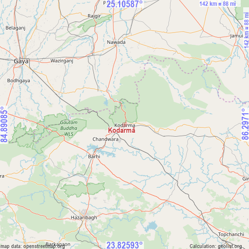
Kodarmā GPS coordinates[2]
24° 28' 3.108" North, 85° 35' 38.292" East
| Map corner | latitude | longitude |
|---|---|---|
| Upper-left | 25.10587°, | 84.89085° |
| Center: | 24.46753°, | 85.59397° |
| Lower-right: | 23.82593°, | 86.2971° |
| Map W x H: | 142.3×142.3 km | = 88.4×88.4mi |
| max Lat: | 34.9274° ⇑39.6% North |
| Kodarmā: | 24.46753° |
| min Lat: | ⇓60.4% South 8.09008° |
| min Long | Kodarmā | max Long |
| 68.82655° | 85.59397° | 96.81° |
| W 85.9%⇐ | ⇒14.1% E |
Elevation
Elevation of Kodarmā is 390 m = 1280 ft, and this is 94.4 m = 310 ft above average elevation for this country.
| Max E: |
3681 m = 12077 ft | 24.8% |
| Kodarmā | 390 m 1280 ft | |
| Avg. | 295.6 m = 970 ft | |
Min E: |
1 m = 3 ft | 75.2% |
See also: India elevation on elevation.city.
Geographical zone
Kodarmā is located in North temperate zone (between Tropic of Cancer and the Arctic Circle). Distance of this Northern Tropic circle is 114.6 km =71.2 mi to South.| Distance of | km | miles | from Kodarmā |
|---|---|---|---|
| North Pole | 7286.5 | 4527.6 | to North |
| Arctic Circle | 4680.6 | 2908.4 | to North |
| Tropic Cancer | 114.6 | 71.2 | to South |
| Equator | 2720.5 | 1690.4 | to South |


Nearby cities:
15 places around Kodarmā: (largest is in red/bold)
• Bagaha
54.4 km =33.8 mi,  277°
277°
• Barki Saria
44.1 km =27.4 mi,  137°
137°
• Buddh Gaya
66.5 km =41.3 mi,  292°
292°
• Dhanwār
39.8 km =24.7 mi,  99°
99°
• Gaya
70 km =43.5 mi,  301°
301°
• Gumia
78.1 km =48.5 mi,  162°
162°
• Hazāribāgh
57.8 km =35.9 mi,  204°
204°
• Hesla
53.5 km =33.2 mi,  147°
147°
• Hisuā
44.4 km =27.6 mi,  336°
336°
• Jumri Tilaiyā
7.5 km =4.7 mi,  240°
240°
• Nawāda
46.9 km =29.1 mi,  353°
353°
• Rājgīr
64.8 km =40.3 mi, 344°
• Silao
70.5 km =43.8 mi, 346°
• Wāris Alīganj
61.3 km =38.1 mi,  4°
4°
• patamda
25.9 km =16.1 mi,  223°
223°
Sources, notices
• [Note1] Compared only with cities in India existing in our database
• [Src1] Map data: © OpenStreetMap contributors (CC-BY-SA)
• [Src2] Other city data from geonames.org with taken over terms of usage.
• [Src3] Geographical zone / Annual Mean Temperature by Robert A. Rohde @ Wikipedia
