Jumri Tilaiyā geodata
Jumri Tilaiyā (Jharkhand) is a populated place; located in India in Asia/Kolkata (GMT+5.5) time zone. With population of 76,341 people, there are 576 cities with bigger population in this country. Compared to other cities in India, 60.3% of cities are located further ↓South; 85.7% of cities are located further ←West and 75.9% of cities have lower elevation than Jumri Tilaiyā. Note1


Jumri Tilaiyā GPS coordinates[2]
24° 26' 5.64" North, 85° 31' 46.236" East
| Map corner | latitude | longitude |
|---|---|---|
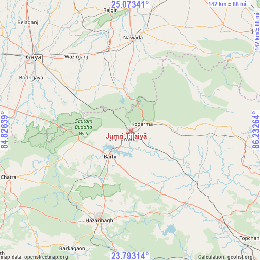
| Upper-left | 25.07341°, | 84.82639° |
| Center: | 24.4349°, | 85.52951° |
| Lower-right: | 23.79314°, | 86.23264° |
| Map W x H: | 142.4×142.4 km | = 88.5×88.5mi |
| max Lat: | 34.9274° ⇑39.7% North |
| Jumri Tilaiyā: | 24.4349° |
| min Lat: | ⇓60.3% South 8.09008° |
| min Long | Jumri Tilaiyā | max Long |
| 68.82655° | 85.52951° | 96.81° |
| W 85.7%⇐ | ⇒14.3% E |
Elevation
Elevation of Jumri Tilaiyā is 398 m = 1306 ft, and this is 102.4 m = 336 ft above average elevation for this country.
| Max E: |
3681 m = 12077 ft | 24.1% |
| Jumri Tilaiyā | 398 m 1306 ft | |
| Avg. | 295.6 m = 970 ft | |
Min E: |
1 m = 3 ft | 75.9% |
See also: Jumri Tilaiyā elevation on elevation.city.
Geographical zone
Jumri Tilaiyā is located in North temperate zone (between Tropic of Cancer and the Arctic Circle). Distance of this Northern Tropic circle is 111 km =69 mi to South.| Distance of | km | miles | from Jumri Tilaiyā |
|---|---|---|---|
| North Pole | 7290.2 | 4529.9 | to North |
| Arctic Circle | 4684.3 | 2910.7 | to North |
| Tropic Cancer | 111 | 69 | to South |
| Equator | 2716.9 | 1688.2 | to South |


Nearby cities:
15 places around Jumri Tilaiyā: (largest is in red/bold)
• Bagaha
48.6 km =30.2 mi,  282°
282°
• Barki Saria
46.5 km =28.9 mi,  128°
128°
• Buddh Gaya
62.2 km =38.6 mi,  298°
298°
• Chatrā
71.4 km =44.4 mi,  249°
249°
• Dhanwār
45.9 km =28.5 mi,  93°
93°
• Gaya
66.7 km =41.4 mi,  307°
307°
• Hazāribāgh
52.1 km =32.4 mi,  199°
199°
• Hesla
54.4 km =33.8 mi,  139°
139°
• Hisuā
45.8 km =28.5 mi,  345°
345°
• Kodarmā
7.5 km =4.7 mi,  60°
60°
• Nawāda
50.3 km =31.3 mi,  1°
1°
• Rājgīr
66.9 km =41.6 mi, 350°
• Silao
72.9 km =45.3 mi, 351°
• Wāris Alīganj
65.7 km =40.8 mi,  9°
9°
• patamda
18.9 km =11.7 mi,  217°
217°
Sources, notices
• [Note1] Compared only with cities in India existing in our database
• [Src1] Map data: © OpenStreetMap contributors (CC-BY-SA)
• [Src2] Other city data from geonames.org with taken over terms of usage.
• [Src3] Geographical zone / Annual Mean Temperature by Robert A. Rohde @ Wikipedia
