Tekāri geodata
Tekāri (Bihar) is a populated place; located in India in Asia/Kolkata (GMT+5.5) time zone. With population of 19,063 people, there are 2115 cities with bigger population in this country. Compared to other cities in India, 63.2% of cities are located further ↓South; 83.9% of cities are located further ←West and 69.1% of cities have higher elevation than Tekāri. Note1


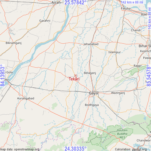
Tekāri GPS coordinates[2]
24° 56' 33.108" North, 84° 50' 33.54" East
| Map corner | latitude | longitude |
|---|---|---|
| Upper-left | 25.57842°, | 84.13953° |
| Center: | 24.94253°, | 84.84265° |
| Lower-right: | 24.30335°, | 85.54578° |
| Map W x H: | 141.8×141.8 km | = 88.1×88.1mi |
| max Lat: | 34.9274° ⇑36.8% North |
| Tekāri: | 24.94253° |
| min Lat: | ⇓63.2% South 8.09008° |
| min Long | Tekāri | max Long |
| 68.82655° | 84.84265° | 96.81° |
| W 83.9%⇐ | ⇒16.1% E |
Elevation
Elevation of Tekāri is 97 m = 318 ft, and this is 198.6 m = 652 ft below average elevation for this country.
| Max E: |
3681 m = 12077 ft | 69.1% |
| Avg. | 295.6 m = 970 ft | |
| Tekāri | 97 m = 318 ft | |
Min E: |
1 m = 3 ft | 30.9% |
See also: India elevation on elevation.city.
Geographical zone
Tekāri is located in North temperate zone (between Tropic of Cancer and the Arctic Circle). Distance of this Northern Tropic circle is 167.4 km =104 mi to South.| Distance of | km | miles | from Tekāri |
|---|---|---|---|
| North Pole | 7233.7 | 4494.8 | to North |
| Arctic Circle | 4627.8 | 2875.6 | to North |
| Tropic Cancer | 167.4 | 104 | to South |
| Equator | 2773.3 | 1723.2 | to South |


Nearby cities:
15 places around Tekāri: (largest is in red/bold)
• Aurangābād
51.8 km =32.2 mi,  245°
245°
• Bagaha
51 km =31.7 mi,  154°
154°
• Buddh Gaya
30.8 km =19.1 mi, 151°
• Daudnagar
45.7 km =28.4 mi,  282°
282°
• Gaya
23 km =14.3 mi,  134°
134°
• Hilsa
60.7 km =37.7 mi,  46°
46°
• Hisuā
59.2 km =36.8 mi,  101°
101°
• Islāmpur
42.7 km =26.5 mi,  58°
58°
• Jahānābād
33.5 km =20.8 mi,  25°
25°
• Masaurhi Buzurg
49.6 km =30.8 mi,  22°
22°
• Nāsriganj
53.2 km =33.1 mi, 283°
• Rafiganj
25.2 km =15.7 mi,  236°
236°
• Rājgīr
59 km =36.7 mi,  80°
80°
• Sherghāti
42.9 km =26.7 mi,  186°
186°
• Silao
61 km =37.9 mi, 75°
Sources, notices
• [Note1] Compared only with cities in India existing in our database
• [Src1] Map data: © OpenStreetMap contributors (CC-BY-SA)
• [Src2] Other city data from geonames.org with taken over terms of usage.
• [Src3] Geographical zone / Annual Mean Temperature by Robert A. Rohde @ Wikipedia
