Bagaha geodata
Bagaha (Bihar) is a populated place; located in India in Asia/Kolkata (GMT+5.5) time zone. With population of 91,383 people, there are 487 cities with bigger population in this country. Compared to other cities in India, 60.9% of cities are located further ↓South; 84.5% of cities are located further ←West and 58.6% of cities have higher elevation than Bagaha. Note1


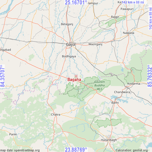
Bagaha GPS coordinates[2]
24° 31' 44.328" North, 85° 3' 36.684" East
| Map corner | latitude | longitude |
|---|---|---|
| Upper-left | 25.16701°, | 84.35707° |
| Center: | 24.52898°, | 85.06019° |
| Lower-right: | 23.88769°, | 85.76332° |
| Map W x H: | 142.2×142.2 km | = 88.4×88.4mi |
| max Lat: | 34.9274° ⇑39.1% North |
| Bagaha: | 24.52898° |
| min Lat: | ⇓60.9% South 8.09008° |
| min Long | Bagaha | max Long |
| 68.82655° | 85.06019° | 96.81° |
| W 84.5%⇐ | ⇒15.5% E |
Elevation
Elevation of Bagaha is 155 m = 509 ft, and this is 140.6 m = 461 ft below average elevation for this country.
| Max E: |
3681 m = 12077 ft | 58.6% |
| Avg. | 295.6 m = 970 ft | |
| Bagaha | 155 m = 509 ft | |
Min E: |
1 m = 3 ft | 41.4% |
See also: Bagaha elevation on elevation.city.
Geographical zone
Bagaha is located in North temperate zone (between Tropic of Cancer and the Arctic Circle). Distance of this Northern Tropic circle is 121.4 km =75.4 mi to South.| Distance of | km | miles | from Bagaha |
|---|---|---|---|
| North Pole | 7279.7 | 4523.4 | to North |
| Arctic Circle | 4673.8 | 2904.2 | to North |
| Tropic Cancer | 121.4 | 75.4 | to South |
| Equator | 2727.4 | 1694.7 | to South |


Nearby cities:
15 places around Bagaha: (largest is in red/bold)
• Buddh Gaya
20.2 km =12.6 mi,  338°
338°
• Chatrā
40.7 km =25.3 mi,  208°
208°
• Gaya
30.3 km =18.8 mi,  349°
349°
• Hazāribāgh
67 km =41.6 mi,  152°
152°
• Hisuā
49.5 km =30.8 mi,  46°
46°
• Islāmpur
69.6 km =43.2 mi,  12°
12°
• Jumri Tilaiyā
48.6 km =30.2 mi,  102°
102°
• Kodarmā
54.4 km =33.8 mi, 97°
• Nawāda
63 km =39.1 mi, 50°
• Rafiganj
53.7 km =33.4 mi,  306°
306°
• Rājgīr
66.4 km =41.3 mi,  33°
33°
• Sherghāti
27.4 km =17 mi,  277°
277°
• Silao
72 km =44.7 mi, 31°
• Tekāri
51 km =31.7 mi,  334°
334°
• patamda
44.2 km =27.5 mi,  125°
125°
Sources, notices
• [Note1] Compared only with cities in India existing in our database
• [Src1] Map data: © OpenStreetMap contributors (CC-BY-SA)
• [Src2] Other city data from geonames.org with taken over terms of usage.
• [Src3] Geographical zone / Annual Mean Temperature by Robert A. Rohde @ Wikipedia
