Buddh Gaya geodata
Buddh Gaya (Bihar) is a populated place; located in India in Asia/Kolkata (GMT+5.5) time zone. With population of 35,188 people, there are 1235 cities with bigger population in this country. Compared to other cities in India, 61.8% of cities are located further ↓South; 84.2% of cities are located further ←West and 64.4% of cities have higher elevation than Buddh Gaya. Note1


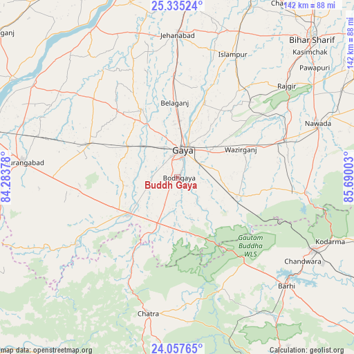
Buddh Gaya GPS coordinates[2]
24° 41' 53.088" North, 84° 59' 12.84" East
| Map corner | latitude | longitude |
|---|---|---|
| Upper-left | 25.33524°, | 84.28378° |
| Center: | 24.69808°, | 84.9869° |
| Lower-right: | 24.05765°, | 85.69003° |
| Map W x H: | 142.1×142.1 km | = 88.3×88.3mi |
| max Lat: | 34.9274° ⇑38.2% North |
| Buddh Gaya: | 24.69808° |
| min Lat: | ⇓61.8% South 8.09008° |
| min Long | Buddh Gaya | max Long |
| 68.82655° | 84.9869° | 96.81° |
| W 84.2%⇐ | ⇒15.8% E |
Elevation
Elevation of Buddh Gaya is 124 m = 407 ft, and this is 171.6 m = 563 ft below average elevation for this country.
| Max E: |
3681 m = 12077 ft | 64.4% |
| Avg. | 295.6 m = 970 ft | |
| Buddh Gaya | 124 m = 407 ft | |
Min E: |
1 m = 3 ft | 35.6% |
See also: India elevation on elevation.city.
Geographical zone
Buddh Gaya is located in North temperate zone (between Tropic of Cancer and the Arctic Circle). Distance of this Northern Tropic circle is 140.3 km =87.2 mi to South.| Distance of | km | miles | from Buddh Gaya |
|---|---|---|---|
| North Pole | 7260.9 | 4511.7 | to North |
| Arctic Circle | 4655 | 2892.5 | to North |
| Tropic Cancer | 140.3 | 87.2 | to South |
| Equator | 2746.2 | 1706.4 | to South |


Nearby cities:
15 places around Buddh Gaya: (largest is in red/bold)
• Aurangābād
62.2 km =38.6 mi,  275°
275°
• Bagaha
20.2 km =12.6 mi,  158°
158°
• Chatrā
55.9 km =34.7 mi,  192°
192°
• Gaya
11.1 km =6.9 mi,  8°
8°
• Hisuā
46 km =28.6 mi,  70°
70°
• Islāmpur
53.9 km =33.5 mi,  24°
24°
• Jahānābād
57.3 km =35.6 mi,  0°
0°
• Jumri Tilaiyā
62.2 km =38.6 mi,  118°
118°
• Nawāda
60 km =37.3 mi, 69°
• Rafiganj
38 km =23.6 mi,  290°
290°
• Rājgīr
57.1 km =35.5 mi,  50°
50°
• Sherghāti
25 km =15.5 mi,  232°
232°
• Silao
61.8 km =38.4 mi, 46°
• Tekāri
30.8 km =19.1 mi,  331°
331°
• patamda
62 km =38.5 mi,  135°
135°
Sources, notices
• [Note1] Compared only with cities in India existing in our database
• [Src1] Map data: © OpenStreetMap contributors (CC-BY-SA)
• [Src2] Other city data from geonames.org with taken over terms of usage.
• [Src3] Geographical zone / Annual Mean Temperature by Robert A. Rohde @ Wikipedia
