Hirekerūr geodata
Hirekerūr (Karnataka) is a populated place; located in India in Asia/Kolkata (GMT+5.5) time zone. With population of 16,688 people, there are 2314 cities with bigger population in this country. Compared to other cities in India, 82.5% of cities are located further ↑North; 79.2% of cities are located further →East and 88.9% of cities have lower elevation than Hirekerūr. Note1


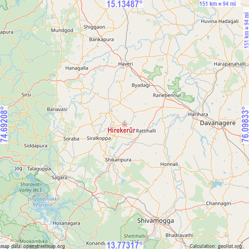
Hirekerūr GPS coordinates[2]
14° 27' 18.216" North, 75° 23' 42.72" East
| Map corner | latitude | longitude |
|---|---|---|
| Upper-left | 15.13487°, | 74.69208° |
| Center: | 14.45506°, | 75.3952° |
| Lower-right: | 13.77317°, | 76.09833° |
| Map W x H: | 151.4×151.4 km | = 94.1×94.1mi |
| max Lat: | 34.9274° ⇑82.5% North |
| Hirekerūr: | 14.45506° |
| min Lat: | ⇓17.5% South 8.09008° |
| min Long | Hirekerūr | max Long |
| 68.82655° | 75.3952° | 96.81° |
| W 20.8%⇐ | ⇒79.2% E |
Elevation
Elevation of Hirekerūr is 611 m = 2005 ft, and this is 315.4 m = 1035 ft above average elevation for this country.
| Max E: |
3681 m = 12077 ft | 11.1% |
| Hirekerūr | 611 m 2005 ft | |
| Avg. | 295.6 m = 970 ft | |
Min E: |
1 m = 3 ft | 88.9% |
See also: India elevation on elevation.city.
Geographical zone
Hirekerūr is located in North Torrid zone (between Equator and Tropic of Cancer). Distance of this Northern Tropic circle is 998.7 km =620.6 mi to North.| Distance of | km | miles | from Hirekerūr |
|---|---|---|---|
| North Pole | 8399.8 | 5219.4 | to North |
| Arctic Circle | 5793.9 | 3600.2 | to North |
| Tropic Cancer | 998.7 | 620.6 | to North |
| Equator | 1607.3 | 998.7 | to South |


Nearby cities:
15 places around Hirekerūr: (largest is in red/bold)
• Beltangadi
53.4 km =33.2 mi,  191°
191°
• Byādgi
26.2 km =16.3 mi,  22°
22°
• Davangere
57.3 km =35.6 mi,  88°
88°
• Harihar
44.8 km =27.8 mi,  81°
81°
• Honnāli
36 km =22.4 mi,  131°
131°
• Hāngal
45.1 km =28 mi,  319°
319°
• Hāveri
37.6 km =23.4 mi,  1°
1°
• Kumsi
44.5 km =27.7 mi,  179°
179°
• Nyāmti
39.3 km =24.4 mi,  150°
150°
• Rānībennur
31.3 km =19.4 mi,  53°
53°
• Savanūr
58 km =36 mi,  353°
353°
• Shikārpur
21 km =13 mi, 191°
• Siddāpur
55.4 km =34.4 mi,  257°
257°
• Sorab
33.7 km =20.9 mi, 255°
• Sāgar
51 km =31.7 mi,  230°
230°
Sources, notices
• [Note1] Compared only with cities in India existing in our database
• [Src1] Map data: © OpenStreetMap contributors (CC-BY-SA)
• [Src2] Other city data from geonames.org with taken over terms of usage.
• [Src3] Geographical zone / Annual Mean Temperature by Robert A. Rohde @ Wikipedia
