Nyāmti geodata
Nyāmti (Karnataka) is a populated place; located in India in Asia/Kolkata (GMT+5.5) time zone. With population of 10,338 people, there are 2908 cities with bigger population in this country. Compared to other cities in India, 83.1% of cities are located further ↑North; 77.9% of cities are located further →East and 88.6% of cities have lower elevation than Nyāmti. Note1


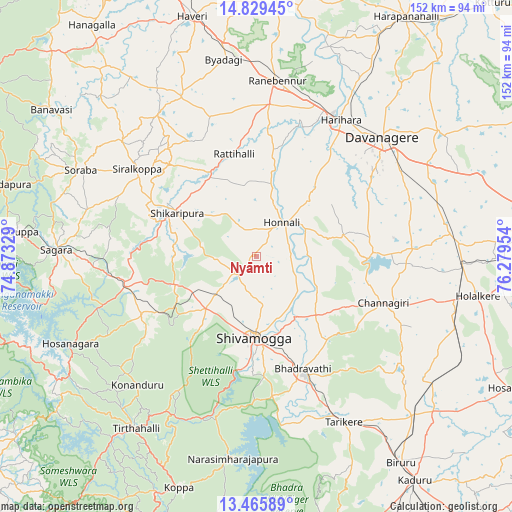
Nyāmti GPS coordinates[2]
14° 8' 55.284" North, 75° 34' 35.076" East
| Map corner | latitude | longitude |
|---|---|---|
| Upper-left | 14.82945°, | 74.87329° |
| Center: | 14.14869°, | 75.57641° |
| Lower-right: | 13.46589°, | 76.27954° |
| Map W x H: | 151.6×151.6 km | = 94.2×94.2mi |
| max Lat: | 34.9274° ⇑83.1% North |
| Nyāmti: | 14.14869° |
| min Lat: | ⇓16.9% South 8.09008° |
| min Long | Nyāmti | max Long |
| 68.82655° | 75.57641° | 96.81° |
| W 22.1%⇐ | ⇒77.9% E |
Elevation
Elevation of Nyāmti is 605 m = 1985 ft, and this is 309.4 m = 1015 ft above average elevation for this country.
| Max E: |
3681 m = 12077 ft | 11.4% |
| Nyāmti | 605 m 1985 ft | |
| Avg. | 295.6 m = 970 ft | |
Min E: |
1 m = 3 ft | 88.6% |
See also: India elevation on elevation.city.
Geographical zone
Nyāmti is located in North Torrid zone (between Equator and Tropic of Cancer). Distance of this Northern Tropic circle is 1032.7 km =641.7 mi to North.| Distance of | km | miles | from Nyāmti |
|---|---|---|---|
| North Pole | 8433.9 | 5240.6 | to North |
| Arctic Circle | 5828 | 3621.4 | to North |
| Tropic Cancer | 1032.7 | 641.7 | to North |
| Equator | 1573.2 | 977.5 | to South |


Nearby cities:
15 places around Nyāmti: (largest is in red/bold)
• Beltangadi
35 km =21.7 mi,  238°
238°
• Bhadrāvati
36.2 km =22.5 mi,  157°
157°
• Channagiri
40.1 km =24.9 mi,  110°
110°
• Davangere
51.8 km =32.2 mi,  46°
46°
• Harihar
47.5 km =29.5 mi,  31°
31°
• Hirekerūr
39.3 km =24.4 mi,  330°
330°
• Honnāli
12.5 km =7.8 mi,  36°
36°
• Kumsi
21.7 km =13.5 mi, 241°
• Māyakonda
56.8 km =35.3 mi,  74°
74°
• Rānībennur
53 km =32.9 mi,  6°
6°
• Shikārpur
27.3 km =17 mi,  299°
299°
• Shimoga
24.2 km =15 mi,  182°
182°
• Sorab
58.3 km =36.2 mi, 296°
• Sāgar
59 km =36.7 mi,  271°
271°
• Tarikere
55.1 km =34.2 mi,  152°
152°
Sources, notices
• [Note1] Compared only with cities in India existing in our database
• [Src1] Map data: © OpenStreetMap contributors (CC-BY-SA)
• [Src2] Other city data from geonames.org with taken over terms of usage.
• [Src3] Geographical zone / Annual Mean Temperature by Robert A. Rohde @ Wikipedia
