Hastināpur geodata
Hastināpur (Uttar Pradesh) is a populated place; located in India in Asia/Kolkata (GMT+5.5) time zone. With population of 24,093 people, there are 1766 cities with bigger population in this country. Compared to other cities in India, 89.6% of cities are located further ↓South; 51.3% of cities are located further →East and 53.8% of cities have lower elevation than Hastināpur. Note1


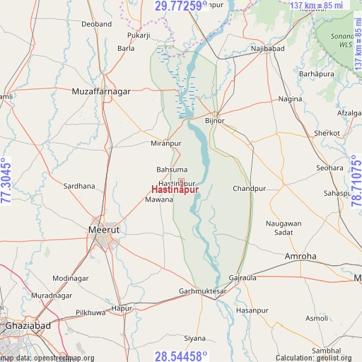
Hastināpur GPS coordinates[2]
29° 9' 37.512" North, 78° 0' 27.432" East
| Map corner | latitude | longitude |
|---|---|---|
| Upper-left | 29.77259°, | 77.3045° |
| Center: | 29.16042°, | 78.00762° |
| Lower-right: | 28.54458°, | 78.71075° |
| Map W x H: | 136.5×136.5 km | = 84.8×84.8mi |
| max Lat: | 34.9274° ⇑10.4% North |
| Hastināpur: | 29.16042° |
| min Lat: | ⇓89.6% South 8.09008° |
| min Long | Hastināpur | max Long |
| 68.82655° | 78.00762° | 96.81° |
| W 48.7%⇐ | ⇒51.3% E |
Elevation
Elevation of Hastināpur is 221 m = 725 ft, and this is 74.6 m = 245 ft below average elevation for this country.
| Max E: |
3681 m = 12077 ft | 46.2% |
| Avg. | 295.6 m = 970 ft | |
| Hastināpur | 221 m = 725 ft | |
Min E: |
1 m = 3 ft | 53.8% |
See also: India elevation on elevation.city.
Geographical zone
Hastināpur is located in North temperate zone (between Tropic of Cancer and the Arctic Circle). Distance of this Northern Tropic circle is 636.4 km =395.4 mi to South.| Distance of | km | miles | from Hastināpur |
|---|---|---|---|
| North Pole | 6764.7 | 4203.4 | to North |
| Arctic Circle | 4158.8 | 2584.2 | to North |
| Tropic Cancer | 636.4 | 395.4 | to South |
| Equator | 3242.3 | 2014.7 | to South |


Nearby cities:
15 places around Hastināpur: (largest is in red/bold)
• Bahsūma
5.6 km =3.5 mi,  322°
322°
• Bijnor
26.7 km =16.6 mi,  27°
27°
• Chāndpur
25.8 km =16 mi,  96°
96°
• Daurāla
29.9 km =18.6 mi,  259°
259°
• Dhanaura
32.9 km =20.4 mi,  132°
132°
• Haldaur
30.5 km =19 mi,  61°
61°
• Jhālu
28.8 km =17.9 mi,  47°
47°
• Jānsath
23.8 km =14.8 mi, 320°
• Khatauli
29.7 km =18.5 mi,  296°
296°
• Kithor
33.3 km =20.7 mi,  191°
191°
• Lāwar Khās
23 km =14.3 mi, 256°
• Mawāna
10.5 km =6.5 mi,  232°
232°
• Mīrānpur
15.5 km =9.6 mi,  338°
338°
• Parīchhatgarh
21.5 km =13.4 mi,  199°
199°
• Phalauda
17.5 km =10.9 mi,  280°
280°
Sources, notices
• [Note1] Compared only with cities in India existing in our database
• [Src1] Map data: © OpenStreetMap contributors (CC-BY-SA)
• [Src2] Other city data from geonames.org with taken over terms of usage.
• [Src3] Geographical zone / Annual Mean Temperature by Robert A. Rohde @ Wikipedia
