Bijnor geodata
Bijnor (Uttar Pradesh) is a populated place; located in India in Asia/Kolkata (GMT+5.5) time zone. With population of 84,593 people, there are 525 cities with bigger population in this country. Compared to other cities in India, 90.5% of cities are located further ↓South; 50.4% of cities are located further ←West and 57.4% of cities have lower elevation than Bijnor. Note1


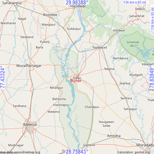
Bijnor GPS coordinates[2]
29° 22' 22.8" North, 78° 8' 10.896" East
| Map corner | latitude | longitude |
|---|---|---|
| Upper-left | 29.98388°, | 77.43324° |
| Center: | 29.373°, | 78.13636° |
| Lower-right: | 28.75843°, | 78.83949° |
| Map W x H: | 136.3×136.3 km | = 84.7×84.7mi |
| max Lat: | 34.9274° ⇑9.5% North |
| Bijnor: | 29.373° |
| min Lat: | ⇓90.5% South 8.09008° |
| min Long | Bijnor | max Long |
| 68.82655° | 78.13636° | 96.81° |
| W 50.4%⇐ | ⇒49.6% E |
Elevation
Elevation of Bijnor is 237 m = 778 ft, and this is 58.6 m = 192 ft below average elevation for this country.
| Max E: |
3681 m = 12077 ft | 42.6% |
| Avg. | 295.6 m = 970 ft | |
| Bijnor | 237 m = 778 ft | |
Min E: |
1 m = 3 ft | 57.4% |
See also: Bijnor elevation on elevation.city.
Geographical zone
Bijnor is located in North temperate zone (between Tropic of Cancer and the Arctic Circle). Distance of this Northern Tropic circle is 660.1 km =410.2 mi to South.| Distance of | km | miles | from Bijnor |
|---|---|---|---|
| North Pole | 6741.1 | 4188.7 | to North |
| Arctic Circle | 4135.2 | 2569.5 | to North |
| Tropic Cancer | 660.1 | 410.2 | to South |
| Equator | 3266 | 2029.4 | to South |


Nearby cities:
15 places around Bijnor: (largest is in red/bold)
• Bahsūma
24.9 km =15.5 mi,  219°
219°
• Chāndpur
29.6 km =18.4 mi,  153°
153°
• Haldaur
17.1 km =10.6 mi,  122°
122°
• Hastināpur
26.7 km =16.6 mi,  207°
207°
• Jhālu
9.6 km =6 mi, 115°
• Jānsath
28.2 km =17.5 mi,  259°
259°
• Kīratpur
16.3 km =10.1 mi,  24°
24°
• Mandāwar
12.7 km =7.9 mi,  356°
356°
• Mawāna
36.5 km =22.7 mi, 214°
• Mīrānpur
20.3 km =12.6 mi,  243°
243°
• Nagīna
30.1 km =18.7 mi,  74°
74°
• Najībābād
33.2 km =20.6 mi,  36°
36°
• Nihtaur
24.9 km =15.5 mi,  102°
102°
• Nūrpur
36.2 km =22.5 mi,  133°
133°
• Phalauda
36.1 km =22.4 mi, 235°
Sources, notices
• [Note1] Compared only with cities in India existing in our database
• [Src1] Map data: © OpenStreetMap contributors (CC-BY-SA)
• [Src2] Other city data from geonames.org with taken over terms of usage.
• [Src3] Geographical zone / Annual Mean Temperature by Robert A. Rohde @ Wikipedia
