Tiptūr geodata
Tiptūr (Karnataka) is a populated place; located in India in Asia/Kolkata (GMT+5.5) time zone. With population of 60,957 people, there are 716 cities with bigger population in this country. Compared to other cities in India, 85.1% of cities are located further ↑North; 68.7% of cities are located further →East and 94.8% of cities have lower elevation than Tiptūr. Note1


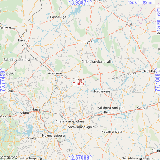
Tiptūr GPS coordinates[2]
13° 15' 22.68" North, 76° 28' 39.648" East
| Map corner | latitude | longitude |
|---|---|---|
| Upper-left | 13.93971°, | 75.77456° |
| Center: | 13.2563°, | 76.47768° |
| Lower-right: | 12.57096°, | 77.18081° |
| Map W x H: | 152.2×152.2 km | = 94.6×94.6mi |
| max Lat: | 34.9274° ⇑85.1% North |
| Tiptūr: | 13.2563° |
| min Lat: | ⇓14.9% South 8.09008° |
| min Long | Tiptūr | max Long |
| 68.82655° | 76.47768° | 96.81° |
| W 31.3%⇐ | ⇒68.7% E |
Elevation
Elevation of Tiptūr is 862 m = 2828 ft, and this is 566.4 m = 1858 ft above average elevation for this country.
| Max E: |
3681 m = 12077 ft | 5.2% |
| Tiptūr | 862 m 2828 ft | |
| Avg. | 295.6 m = 970 ft | |
Min E: |
1 m = 3 ft | 94.8% |
See also: Tiptūr elevation on elevation.city.
Geographical zone
Tiptūr is located in North Torrid zone (between Equator and Tropic of Cancer). Distance of this Northern Tropic circle is 1132 km =703.4 mi to North.| Distance of | km | miles | from Tiptūr |
|---|---|---|---|
| North Pole | 8533.1 | 5302.2 | to North |
| Arctic Circle | 5927.2 | 3683 | to North |
| Tropic Cancer | 1132 | 703.4 | to North |
| Equator | 1474 | 915.9 | to South |


Nearby cities:
15 places around Tiptūr: (largest is in red/bold)
• Alūr
61.1 km =38 mi,  239°
239°
• Arsikere
24.7 km =15.3 mi,  285°
285°
• Bellūru
41.2 km =25.6 mi,  137°
137°
• Bānāvar
38.1 km =23.7 mi,  296°
296°
• Channarāyapatna
40.1 km =24.9 mi,  194°
194°
• Chiknāyakanhalli
23.6 km =14.7 mi,  41°
41°
• Gubbi
50.5 km =31.4 mi,  82°
82°
• Hassan
49.7 km =30.9 mi, 236°
• Hole Narsipur
58.1 km =36.1 mi,  205°
205°
• Hosdurga
63.6 km =39.5 mi,  340°
340°
• Kadūr
60.2 km =37.4 mi, 303°
• Kunigal
64.7 km =40.2 mi,  113°
113°
• Nāgamangala
57.1 km =35.5 mi,  148°
148°
• Srāvana Belgola
44.4 km =27.6 mi,  178°
178°
• Turuvekere
22.9 km =14.2 mi,  116°
116°
Sources, notices
• [Note1] Compared only with cities in India existing in our database
• [Src1] Map data: © OpenStreetMap contributors (CC-BY-SA)
• [Src2] Other city data from geonames.org with taken over terms of usage.
• [Src3] Geographical zone / Annual Mean Temperature by Robert A. Rohde @ Wikipedia
