Kānodar geodata
Kānodar (Gujarat) is a populated place; located in India in Asia/Kolkata (GMT+5.5) time zone. With population of 11,953 people, there are 2745 cities with bigger population in this country. Compared to other cities in India, 58.6% of cities are located further ↓South; 96.9% of cities are located further →East and 54% of cities have higher elevation than Kānodar. Note1


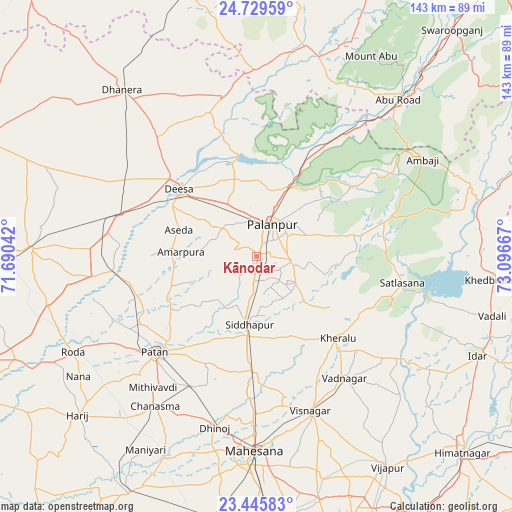
Kānodar GPS coordinates[2]
24° 5' 21.552" North, 72° 23' 36.744" East
| Map corner | latitude | longitude |
|---|---|---|
| Upper-left | 24.72959°, | 71.69042° |
| Center: | 24.08932°, | 72.39354° |
| Lower-right: | 23.44583°, | 73.09667° |
| Map W x H: | 142.7×142.7 km | = 88.7×88.7mi |
| max Lat: | 34.9274° ⇑41.4% North |
| Kānodar: | 24.08932° |
| min Lat: | ⇓58.6% South 8.09008° |
| min Long | Kānodar | max Long |
| 68.82655° | 72.39354° | 96.81° |
| W 3.1%⇐ | ⇒96.9% E |
Elevation
Elevation of Kānodar is 180 m = 591 ft, and this is 115.6 m = 379 ft below average elevation for this country.
| Max E: |
3681 m = 12077 ft | 54% |
| Avg. | 295.6 m = 970 ft | |
| Kānodar | 180 m = 591 ft | |
Min E: |
1 m = 3 ft | 46% |
See also: India elevation on elevation.city.
Geographical zone
Kānodar is located in North temperate zone (between Tropic of Cancer and the Arctic Circle). Distance of this Northern Tropic circle is 72.6 km =45.1 mi to South.| Distance of | km | miles | from Kānodar |
|---|---|---|---|
| North Pole | 7328.6 | 4553.8 | to North |
| Arctic Circle | 4722.7 | 2934.5 | to North |
| Tropic Cancer | 72.6 | 45.1 | to South |
| Equator | 2678.5 | 1664.3 | to South |


Nearby cities:
15 places around Kānodar: (largest is in red/bold)
• Chānasma
50.5 km =31.4 mi,  214°
214°
• Dhanera
59.9 km =37.2 mi,  321°
321°
• Dīsa
28.6 km =17.8 mi,  310°
310°
• Hārij
66.2 km =41.1 mi,  228°
228°
• Khedbrahma
66.6 km =41.4 mi,  95°
95°
• Kherālu
32.2 km =20 mi,  134°
134°
• Pālanpur
10.2 km =6.3 mi,  26°
26°
• Pātan
37.7 km =23.4 mi, 225°
• Siddhapur
19.2 km =11.9 mi,  186°
186°
• Un
67.2 km =41.8 mi,  250°
250°
• Unjha
31.8 km =19.8 mi,  180°
180°
• Vadnagar
42 km =26.1 mi,  143°
143°
• Visnagar
46.3 km =28.8 mi,  159°
159°
• Ābu
65 km =40.4 mi, 30°
• Ābu Road
58.6 km =36.4 mi,  42°
42°
Sources, notices
• [Note1] Compared only with cities in India existing in our database
• [Src1] Map data: © OpenStreetMap contributors (CC-BY-SA)
• [Src2] Other city data from geonames.org with taken over terms of usage.
• [Src3] Geographical zone / Annual Mean Temperature by Robert A. Rohde @ Wikipedia
