Dīsa geodata
Dīsa (Gujarat) is a populated place; located in India in Asia/Kolkata (GMT+5.5) time zone. With population of 92,224 people, there are 482 cities with bigger population in this country. Compared to other cities in India, 59.3% of cities are located further ↓South; 97.2% of cities are located further →East and 63.1% of cities have higher elevation than Dīsa. Note1


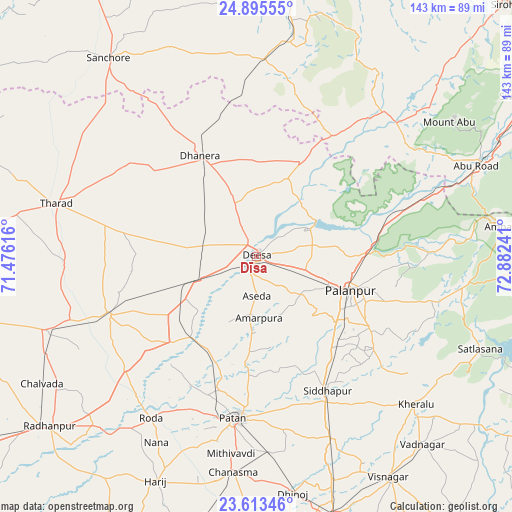
Dīsa GPS coordinates[2]
24° 15' 22.032" North, 72° 10' 45.408" East
| Map corner | latitude | longitude |
|---|---|---|
| Upper-left | 24.89555°, | 71.47616° |
| Center: | 24.25612°, | 72.17928° |
| Lower-right: | 23.61346°, | 72.88241° |
| Map W x H: | 142.6×142.6 km | = 88.6×88.6mi |
| max Lat: | 34.9274° ⇑40.7% North |
| Dīsa: | 24.25612° |
| min Lat: | ⇓59.3% South 8.09008° |
| min Long | Dīsa | max Long |
| 68.82655° | 72.17928° | 96.81° |
| W 2.8%⇐ | ⇒97.2% E |
Elevation
Elevation of Dīsa is 132 m = 433 ft, and this is 163.6 m = 537 ft below average elevation for this country.
| Max E: |
3681 m = 12077 ft | 63.1% |
| Avg. | 295.6 m = 970 ft | |
| Dīsa | 132 m = 433 ft | |
Min E: |
1 m = 3 ft | 36.9% |
See also: Dīsa elevation on elevation.city.
Geographical zone
Dīsa is located in North temperate zone (between Tropic of Cancer and the Arctic Circle). Distance of this Northern Tropic circle is 91.1 km =56.6 mi to South.| Distance of | km | miles | from Dīsa |
|---|---|---|---|
| North Pole | 7310 | 4542.2 | to North |
| Arctic Circle | 4704.1 | 2923 | to North |
| Tropic Cancer | 91.1 | 56.6 | to South |
| Equator | 2697 | 1675.8 | to South |


Nearby cities:
15 places around Dīsa: (largest is in red/bold)
• Chānasma
60.6 km =37.7 mi,  186°
186°
• Dhanera
32.3 km =20.1 mi,  330°
330°
• Hārij
68.4 km =42.5 mi,  203°
203°
• Kherālu
60.7 km =37.7 mi,  132°
132°
• Kānodar
28.6 km =17.8 mi, 130°
• Pālanpur
27.9 km =17.3 mi,  109°
109°
• Pātan
45.4 km =28.2 mi, 186°
• Siddhapur
42.4 km =26.3 mi,  152°
152°
• Sānchor
68.9 km =42.8 mi,  323°
323°
• Tharād
58.2 km =36.2 mi,  285°
285°
• Un
58.4 km =36.3 mi,  225°
225°
• Unjha
54.7 km =34 mi,  156°
156°
• Vadnagar
70.1 km =43.6 mi,  138°
138°
• Ābu
66.2 km =41.1 mi,  55°
55°
• Ābu Road
65.9 km =40.9 mi,  67°
67°
Sources, notices
• [Note1] Compared only with cities in India existing in our database
• [Src1] Map data: © OpenStreetMap contributors (CC-BY-SA)
• [Src2] Other city data from geonames.org with taken over terms of usage.
• [Src3] Geographical zone / Annual Mean Temperature by Robert A. Rohde @ Wikipedia
