Bahua geodata
Bahua (Uttar Pradesh) is a populated place; located in India in Asia/Kolkata (GMT+5.5) time zone. With population of 10,243 people, there are 2917 cities with bigger population in this country. Compared to other cities in India, 69.2% of cities are located further ↓South; 71.5% of cities are located further ←West and 64.6% of cities have higher elevation than Bahua. Note1


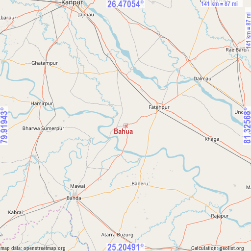
Bahua GPS coordinates[2]
25° 50' 21.912" North, 80° 37' 21.18" East
| Map corner | latitude | longitude |
|---|---|---|
| Upper-left | 26.47054°, | 79.91943° |
| Center: | 25.83942°, | 80.62255° |
| Lower-right: | 25.20491°, | 81.32568° |
| Map W x H: | 140.7×140.7 km | = 87.4×87.4mi |
| max Lat: | 34.9274° ⇑30.8% North |
| Bahua: | 25.83942° |
| min Lat: | ⇓69.2% South 8.09008° |
| min Long | Bahua | max Long |
| 68.82655° | 80.62255° | 96.81° |
| W 71.5%⇐ | ⇒28.5% E |
Elevation
Elevation of Bahua is 123 m = 404 ft, and this is 172.6 m = 566 ft below average elevation for this country.
| Max E: |
3681 m = 12077 ft | 64.6% |
| Avg. | 295.6 m = 970 ft | |
| Bahua | 123 m = 404 ft | |
Min E: |
1 m = 3 ft | 35.4% |
See also: India elevation on elevation.city.
Geographical zone
Bahua is located in North temperate zone (between Tropic of Cancer and the Arctic Circle). Distance of this Northern Tropic circle is 267.2 km =166 mi to South.| Distance of | km | miles | from Bahua |
|---|---|---|---|
| North Pole | 7134 | 4432.9 | to North |
| Arctic Circle | 4528.1 | 2813.6 | to North |
| Tropic Cancer | 267.2 | 166 | to South |
| Equator | 2873.1 | 1785.3 | to South |


Nearby cities:
15 places around Bahua: (largest is in red/bold)
• Baberu
33.5 km =20.8 mi,  165°
165°
• Bhagwantnagar
44.8 km =27.8 mi,  17°
17°
• Bindki
22.4 km =13.9 mi,  348°
348°
• Bisenda Buzurg
48.5 km =30.1 mi,  180°
180°
• Bānda
49.5 km =30.8 mi,  215°
215°
• Bīghāpur Khurd
56.6 km =35.2 mi,  3°
3°
• Dalmau
47.8 km =29.7 mi,  58°
58°
• Fatehpur
21.4 km =13.3 mi, 62°
• Ghātampur
57.2 km =35.5 mi,  307°
307°
• Hamīrpur
49.1 km =30.5 mi,  285°
285°
• Khāga
48.8 km =30.3 mi,  98°
98°
• Kishanpur
45.7 km =28.4 mi,  118°
118°
• Maudaha
53.8 km =33.4 mi,  251°
251°
• Oran
53.7 km =33.4 mi, 167°
• Tindwāri
26.5 km =16.5 mi,  201°
201°
Sources, notices
• [Note1] Compared only with cities in India existing in our database
• [Src1] Map data: © OpenStreetMap contributors (CC-BY-SA)
• [Src2] Other city data from geonames.org with taken over terms of usage.
• [Src3] Geographical zone / Annual Mean Temperature by Robert A. Rohde @ Wikipedia
