Bindki geodata
Bindki (Uttar Pradesh) is a populated place; located in India in Asia/Kolkata (GMT+5.5) time zone. With population of 36,058 people, there are 1208 cities with bigger population in this country. Compared to other cities in India, 70.7% of cities are located further ↓South; 71.3% of cities are located further ←West and 64.3% of cities have higher elevation than Bindki. Note1


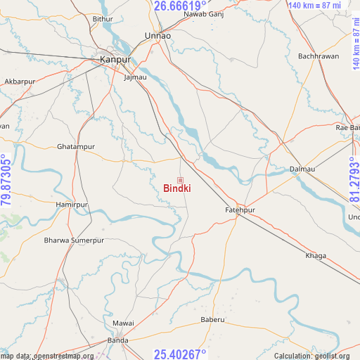
Bindki GPS coordinates[2]
26° 2' 10.068" North, 80° 34' 34.212" East
| Map corner | latitude | longitude |
|---|---|---|
| Upper-left | 26.66619°, | 79.87305° |
| Center: | 26.03613°, | 80.57617° |
| Lower-right: | 25.40267°, | 81.2793° |
| Map W x H: | 140.5×140.5 km | = 87.3×87.3mi |
| max Lat: | 34.9274° ⇑29.3% North |
| Bindki: | 26.03613° |
| min Lat: | ⇓70.7% South 8.09008° |
| min Long | Bindki | max Long |
| 68.82655° | 80.57617° | 96.81° |
| W 71.3%⇐ | ⇒28.7% E |
Elevation
Elevation of Bindki is 125 m = 410 ft, and this is 170.6 m = 560 ft below average elevation for this country.
| Max E: |
3681 m = 12077 ft | 64.3% |
| Avg. | 295.6 m = 970 ft | |
| Bindki | 125 m = 410 ft | |
Min E: |
1 m = 3 ft | 35.7% |
See also: India elevation on elevation.city.
Geographical zone
Bindki is located in North temperate zone (between Tropic of Cancer and the Arctic Circle). Distance of this Northern Tropic circle is 289 km =179.6 mi to South.| Distance of | km | miles | from Bindki |
|---|---|---|---|
| North Pole | 7112.1 | 4419.3 | to North |
| Arctic Circle | 4506.2 | 2800 | to North |
| Tropic Cancer | 289 | 179.6 | to South |
| Equator | 2894.9 | 1798.8 | to South |


Nearby cities:
15 places around Bindki: (largest is in red/bold)
• Baberu
55.9 km =34.7 mi,  166°
166°
• Bahua
22.4 km =13.9 mi, 168°
• Bhagwantnagar
27.6 km =17.1 mi,  40°
40°
• Bīghāpur Khurd
35.5 km =22.1 mi,  13°
13°
• Dalmau
45.4 km =28.2 mi,  85°
85°
• Fatehpur
26.5 km =16.5 mi,  117°
117°
• Ghātampur
42.8 km =26.6 mi,  287°
287°
• Hamīrpur
43.7 km =27.2 mi,  258°
258°
• Kanpur
52.8 km =32.8 mi,  334°
334°
• Kurāra
58.9 km =36.6 mi, 263°
• Maurānwān
53.1 km =33 mi,  34°
34°
• Nawābganj
57.8 km =35.9 mi, 332°
• Purwā
50.8 km =31.6 mi,  22°
22°
• Tindwāri
46.8 km =29.1 mi,  186°
186°
• Unnāo
57.5 km =35.7 mi,  351°
351°
Sources, notices
• [Note1] Compared only with cities in India existing in our database
• [Src1] Map data: © OpenStreetMap contributors (CC-BY-SA)
• [Src2] Other city data from geonames.org with taken over terms of usage.
• [Src3] Geographical zone / Annual Mean Temperature by Robert A. Rohde @ Wikipedia
