Tindwāri geodata
Tindwāri (Uttar Pradesh) is a populated place; located in India in Asia/Kolkata (GMT+5.5) time zone. With population of 10,406 people, there are 2902 cities with bigger population in this country. Compared to other cities in India, 67.8% of cities are located further ↓South; 71% of cities are located further ←West and 64.8% of cities have higher elevation than Tindwāri. Note1


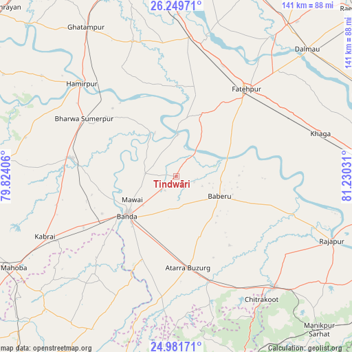
Tindwāri GPS coordinates[2]
25° 37' 2.604" North, 80° 31' 37.848" East
| Map corner | latitude | longitude |
|---|---|---|
| Upper-left | 26.24971°, | 79.82406° |
| Center: | 25.61739°, | 80.52718° |
| Lower-right: | 24.98171°, | 81.23031° |
| Map W x H: | 141×141 km | = 87.6×87.6mi |
| max Lat: | 34.9274° ⇑32.2% North |
| Tindwāri: | 25.61739° |
| min Lat: | ⇓67.8% South 8.09008° |
| min Long | Tindwāri | max Long |
| 68.82655° | 80.52718° | 96.81° |
| W 71%⇐ | ⇒29% E |
Elevation
Elevation of Tindwāri is 121 m = 397 ft, and this is 174.6 m = 573 ft below average elevation for this country.
| Max E: |
3681 m = 12077 ft | 64.8% |
| Avg. | 295.6 m = 970 ft | |
| Tindwāri | 121 m = 397 ft | |
Min E: |
1 m = 3 ft | 35.2% |
See also: India elevation on elevation.city.
Geographical zone
Tindwāri is located in North temperate zone (between Tropic of Cancer and the Arctic Circle). Distance of this Northern Tropic circle is 242.5 km =150.7 mi to South.| Distance of | km | miles | from Tindwāri |
|---|---|---|---|
| North Pole | 7158.7 | 4448.2 | to North |
| Arctic Circle | 4552.8 | 2829 | to North |
| Tropic Cancer | 242.5 | 150.7 | to South |
| Equator | 2848.4 | 1769.9 | to South |


Nearby cities:
15 places around Tindwāri: (largest is in red/bold)
• Atarra
37.1 km =23.1 mi,  173°
173°
• Baberu
19.4 km =12.1 mi,  113°
113°
• Bahua
26.5 km =16.5 mi,  21°
21°
• Bindki
46.8 km =29.1 mi,  6°
6°
• Bisenda Buzurg
25.5 km =15.8 mi,  158°
158°
• Bānda
24.8 km =15.4 mi,  231°
231°
• Fatehpur
44.8 km =27.8 mi,  39°
39°
• Hamīrpur
53.4 km =33.2 mi,  314°
314°
• Kabrāi
58.1 km =36.1 mi,  245°
245°
• Khāga
60.3 km =37.5 mi,  73°
73°
• Kishanpur
49.8 km =30.9 mi,  86°
86°
• Mataundh
42.3 km =26.3 mi,  241°
241°
• Maudaha
42 km =26.1 mi,  280°
280°
• Naraini
47.8 km =29.7 mi,  186°
186°
• Oran
35.1 km =21.8 mi,  142°
142°
Sources, notices
• [Note1] Compared only with cities in India existing in our database
• [Src1] Map data: © OpenStreetMap contributors (CC-BY-SA)
• [Src2] Other city data from geonames.org with taken over terms of usage.
• [Src3] Geographical zone / Annual Mean Temperature by Robert A. Rohde @ Wikipedia
