Akbarpur geodata
Akbarpur (Uttar Pradesh) is a populated place; located in India in Asia/Kolkata (GMT+5.5) time zone. With population of 18,835 people, there are 2142 cities with bigger population in this country. Compared to other cities in India, 73.7% of cities are located further ↓South; 67.4% of cities are located further ←West and 62.5% of cities have higher elevation than Akbarpur. Note1


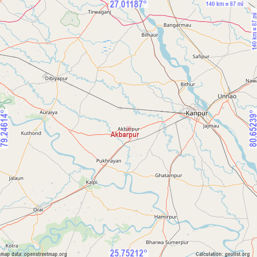
Akbarpur GPS coordinates[2]
26° 23' 1.356" North, 79° 56' 57.336" East
| Map corner | latitude | longitude |
|---|---|---|
| Upper-left | 27.01187°, | 79.24614° |
| Center: | 26.38371°, | 79.94926° |
| Lower-right: | 25.75212°, | 80.65239° |
| Map W x H: | 140.1×140.1 km | = 87.1×87.1mi |
| max Lat: | 34.9274° ⇑26.3% North |
| Akbarpur: | 26.38371° |
| min Lat: | ⇓73.7% South 8.09008° |
| min Long | Akbarpur | max Long |
| 68.82655° | 79.94926° | 96.81° |
| W 67.4%⇐ | ⇒32.6% E |
Elevation
Elevation of Akbarpur is 135 m = 443 ft, and this is 160.6 m = 527 ft below average elevation for this country.
| Max E: |
3681 m = 12077 ft | 62.5% |
| Avg. | 295.6 m = 970 ft | |
| Akbarpur | 135 m = 443 ft | |
Min E: |
1 m = 3 ft | 37.5% |
See also: India elevation on elevation.city.
Geographical zone
Akbarpur is located in North temperate zone (between Tropic of Cancer and the Arctic Circle). Distance of this Northern Tropic circle is 327.7 km =203.6 mi to South.| Distance of | km | miles | from Akbarpur |
|---|---|---|---|
| North Pole | 7073.5 | 4395.3 | to North |
| Arctic Circle | 4467.6 | 2776 | to North |
| Tropic Cancer | 327.7 | 203.6 | to South |
| Equator | 2933.6 | 1822.9 | to South |


Nearby cities:
15 places around Akbarpur: (largest is in red/bold)
• Auraiya
44.7 km =27.8 mi,  281°
281°
• Bilhaur
52.4 km =32.6 mi,  12°
12°
• Bithūr
40.5 km =25.2 mi,  52°
52°
• Ghātampur
33.7 km =20.9 mi,  139°
139°
• Hamīrpur
51.6 km =32.1 mi,  157°
157°
• Jhīnjhak
29.1 km =18.1 mi,  312°
312°
• Kadaura
45.7 km =28.4 mi,  194°
194°
• Kanpur
40.9 km =25.4 mi,  77°
77°
• Kurāra
45 km =28 mi,  174°
174°
• Kālpi
36.7 km =22.8 mi,  215°
215°
• Nawābganj
38 km =23.6 mi,  70°
70°
• Phaphūnd
53.9 km =33.5 mi,  296°
296°
• Pukhrāyān
21 km =13 mi,  212°
212°
• Rura
12.8 km =8 mi,  337°
337°
• Sikandra
31.9 km =19.8 mi,  266°
266°
Sources, notices
• [Note1] Compared only with cities in India existing in our database
• [Src1] Map data: © OpenStreetMap contributors (CC-BY-SA)
• [Src2] Other city data from geonames.org with taken over terms of usage.
• [Src3] Geographical zone / Annual Mean Temperature by Robert A. Rohde @ Wikipedia
