Ghātampur geodata
Ghātampur (Uttar Pradesh) is a populated place; located in India in Asia/Kolkata (GMT+5.5) time zone. With population of 40,435 people, there are 1089 cities with bigger population in this country. Compared to other cities in India, 71.6% of cities are located further ↓South; 69.3% of cities are located further ←West and 63.8% of cities have higher elevation than Ghātampur. Note1


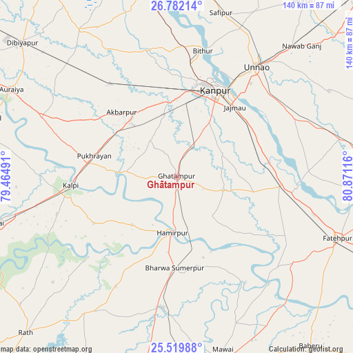
Ghātampur GPS coordinates[2]
26° 9' 9.792" North, 80° 10' 4.908" East
| Map corner | latitude | longitude |
|---|---|---|
| Upper-left | 26.78214°, | 79.46491° |
| Center: | 26.15272°, | 80.16803° |
| Lower-right: | 25.51988°, | 80.87116° |
| Map W x H: | 140.4×140.4 km | = 87.2×87.2mi |
| max Lat: | 34.9274° ⇑28.4% North |
| Ghātampur: | 26.15272° |
| min Lat: | ⇓71.6% South 8.09008° |
| min Long | Ghātampur | max Long |
| 68.82655° | 80.16803° | 96.81° |
| W 69.3%⇐ | ⇒30.7% E |
Elevation
Elevation of Ghātampur is 128 m = 420 ft, and this is 167.6 m = 550 ft below average elevation for this country.
| Max E: |
3681 m = 12077 ft | 63.8% |
| Avg. | 295.6 m = 970 ft | |
| Ghātampur | 128 m = 420 ft | |
Min E: |
1 m = 3 ft | 36.2% |
See also: Ghātampur elevation on elevation.city.
Geographical zone
Ghātampur is located in North temperate zone (between Tropic of Cancer and the Arctic Circle). Distance of this Northern Tropic circle is 302 km =187.7 mi to South.| Distance of | km | miles | from Ghātampur |
|---|---|---|---|
| North Pole | 7099.2 | 4411.2 | to North |
| Arctic Circle | 4493.3 | 2792 | to North |
| Tropic Cancer | 302 | 187.7 | to South |
| Equator | 2907.9 | 1806.9 | to South |


Nearby cities:
15 places around Ghātampur: (largest is in red/bold)
• Akbarpur
33.7 km =20.9 mi,  319°
319°
• Bahua
57.2 km =35.5 mi,  127°
127°
• Bindki
42.8 km =26.6 mi,  107°
107°
• Bithūr
51.5 km =32 mi,  11°
11°
• Bīghāpur Khurd
53.3 km =33.1 mi,  66°
66°
• Hamīrpur
22 km =13.7 mi,  185°
185°
• Kadaura
37.8 km =23.5 mi,  240°
240°
• Kanpur
39.2 km =24.4 mi,  27°
27°
• Kurāra
26.1 km =16.2 mi,  222°
222°
• Kālpi
43.6 km =27.1 mi,  264°
264°
• Maudaha
52.5 km =32.6 mi, 185°
• Nawābganj
40.8 km =25.4 mi,  20°
20°
• Pukhrāyān
33.9 km =21.1 mi,  283°
283°
• Rura
46 km =28.6 mi, 324°
• Unnāo
54.2 km =33.7 mi,  36°
36°
Sources, notices
• [Note1] Compared only with cities in India existing in our database
• [Src1] Map data: © OpenStreetMap contributors (CC-BY-SA)
• [Src2] Other city data from geonames.org with taken over terms of usage.
• [Src3] Geographical zone / Annual Mean Temperature by Robert A. Rohde @ Wikipedia
