Dohad geodata
Dohad (Gujarat) is a populated place; located in India in Asia/Kolkata (GMT+5.5) time zone. With population of 83,966 people, there are 528 cities with bigger population in this country. Compared to other cities in India, 50.3% of cities are located further ↓South; 88.1% of cities are located further →East and 68.3% of cities have lower elevation than Dohad. Note1


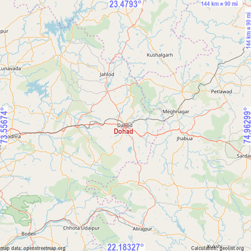
Dohad GPS coordinates[2]
22° 49' 58.188" North, 74° 15' 35.496" East
| Map corner | latitude | longitude |
|---|---|---|
| Upper-left | 23.4793°, | 73.55674° |
| Center: | 22.83283°, | 74.25986° |
| Lower-right: | 22.18327°, | 74.96299° |
| Map W x H: | 144.1×144.1 km | = 89.5×89.5mi |
| max Lat: | 34.9274° ⇑49.7% North |
| Dohad: | 22.83283° |
| min Lat: | ⇓50.3% South 8.09008° |
| min Long | Dohad | max Long |
| 68.82655° | 74.25986° | 96.81° |
| W 11.9%⇐ | ⇒88.1% E |
Elevation
Elevation of Dohad is 310 m = 1017 ft, and this is 14.4 m = 47 ft above average elevation for this country.
| Max E: |
3681 m = 12077 ft | 31.7% |
| Dohad | 310 m 1017 ft | |
| Avg. | 295.6 m = 970 ft | |
Min E: |
1 m = 3 ft | 68.3% |
See also: Dohad elevation on elevation.city.
Geographical zone
Dohad is located in North Torrid zone (between Equator and Tropic of Cancer). Distance of this Northern Tropic circle is 67.1 km =41.7 mi to North.| Distance of | km | miles | from Dohad |
|---|---|---|---|
| North Pole | 7468.3 | 4640.6 | to North |
| Arctic Circle | 4862.4 | 3021.4 | to North |
| Tropic Cancer | 67.1 | 41.7 | to North |
| Equator | 2538.8 | 1577.5 | to South |


Nearby cities:
15 places around Dohad: (largest is in red/bold)
• Bamna
59 km =36.7 mi,  60°
60°
• Bhābhra
34.3 km =21.3 mi,  168°
168°
• Chhota Udepur
63.9 km =39.7 mi,  203°
203°
• Devgadh Bāriya
38.7 km =24 mi,  248°
248°
• Godhra
66.4 km =41.3 mi,  264°
264°
• Jetpur
69.2 km =43 mi,  218°
218°
• Jhābua
34.7 km =21.6 mi,  102°
102°
• Jobat
56.1 km =34.9 mi,  145°
145°
• Kushālgarh
45.2 km =28.1 mi,  25°
25°
• Morwa
43.8 km =27.2 mi,  280°
280°
• Petlāwad
58.5 km =36.4 mi,  70°
70°
• Rajpur
59.6 km =37 mi, 170°
• Rājgarh
72.3 km =44.9 mi, 103°
• Rānāpur
33.8 km =21 mi,  127°
127°
• Thandla
38 km =23.6 mi, 58°
Sources, notices
• [Note1] Compared only with cities in India existing in our database
• [Src1] Map data: © OpenStreetMap contributors (CC-BY-SA)
• [Src2] Other city data from geonames.org with taken over terms of usage.
• [Src3] Geographical zone / Annual Mean Temperature by Robert A. Rohde @ Wikipedia
