Lūnāvāda geodata
Lūnāvāda (Gujarat) is a seat of a second-order administrative division; located in India in Asia/Kolkata (GMT+5.5) time zone. With population of 35,431 people, there are 1226 cities with bigger population in this country. Compared to other cities in India, 52.4% of cities are located further ↓South; 92.1% of cities are located further →East and 67.6% of cities have higher elevation than Lūnāvāda. Note1


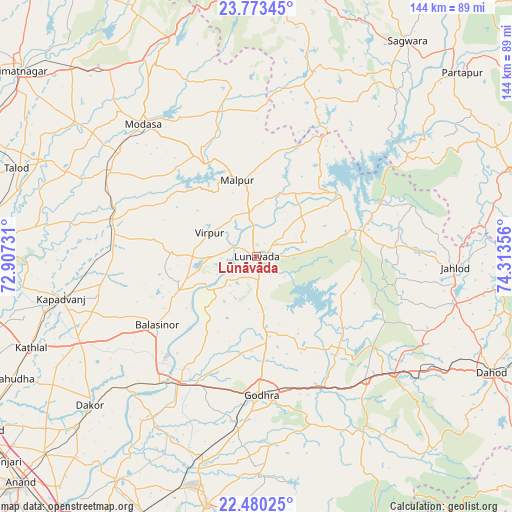
Lūnāvāda GPS coordinates[2]
23° 7' 42.276" North, 73° 36' 37.548" East
| Map corner | latitude | longitude |
|---|---|---|
| Upper-left | 23.77345°, | 72.90731° |
| Center: | 23.12841°, | 73.61043° |
| Lower-right: | 22.48025°, | 74.31356° |
| Map W x H: | 143.8×143.8 km | = 89.4×89.4mi |
| max Lat: | 34.9274° ⇑47.6% North |
| Lūnāvāda: | 23.12841° |
| min Lat: | ⇓52.4% South 8.09008° |
| min Long | Lūnāvāda | max Long |
| 68.82655° | 73.61043° | 96.81° |
| W 7.9%⇐ | ⇒92.1% E |
Elevation
Elevation of Lūnāvāda is 104 m = 341 ft, and this is 191.6 m = 629 ft below average elevation for this country.
| Max E: |
3681 m = 12077 ft | 67.6% |
| Avg. | 295.6 m = 970 ft | |
| Lūnāvāda | 104 m = 341 ft | |
Min E: |
1 m = 3 ft | 32.4% |
See also: India elevation on elevation.city.
Geographical zone
Lūnāvāda is located in North Torrid zone (between Equator and Tropic of Cancer). Distance of this Northern Tropic circle is 34.3 km =21.3 mi to North.| Distance of | km | miles | from Lūnāvāda |
|---|---|---|---|
| North Pole | 7435.4 | 4620.1 | to North |
| Arctic Circle | 4829.5 | 3000.9 | to North |
| Tropic Cancer | 34.3 | 21.3 | to North |
| Equator | 2571.6 | 1597.9 | to South |


Nearby cities:
15 places around Lūnāvāda: (largest is in red/bold)
• Devgadh Bāriya
56.1 km =34.9 mi,  147°
147°
• Dākor
63 km =39.1 mi,  228°
228°
• Galiākot
60.4 km =37.5 mi,  43°
43°
• Godhra
39.2 km =24.4 mi,  179°
179°
• Hālol
70.9 km =44.1 mi,  191°
191°
• Kapadvanj
56.4 km =35 mi,  258°
258°
• Kālol
59.8 km =37.2 mi, 194°
• Meghraj
42.3 km =26.3 mi,  346°
346°
• Modāsa
48.9 km =30.4 mi,  319°
319°
• Morwa
34.2 km =21.3 mi,  136°
136°
• Mālpur
29.7 km =18.5 mi,  330°
330°
• Thāsra
54.9 km =34.1 mi, 228°
• Umreth
69.6 km =43.2 mi, 226°
• Vejalpur
49 km =30.4 mi, 185°
• Virpur
15 km =9.3 mi,  296°
296°
Sources, notices
• [Note1] Compared only with cities in India existing in our database
• [Src1] Map data: © OpenStreetMap contributors (CC-BY-SA)
• [Src2] Other city data from geonames.org with taken over terms of usage.
• [Src3] Geographical zone / Annual Mean Temperature by Robert A. Rohde @ Wikipedia
