Rura geodata
Rura (Uttar Pradesh) is a populated place; located in India in Asia/Kolkata (GMT+5.5) time zone. With population of 15,908 people, there are 2377 cities with bigger population in this country. Compared to other cities in India, 74.6% of cities are located further ↓South; 67% of cities are located further ←West and 61.5% of cities have higher elevation than Rura. Note1


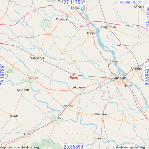
Rura GPS coordinates[2]
26° 29' 24.036" North, 79° 54' 3.888" East
| Map corner | latitude | longitude |
|---|---|---|
| Upper-left | 27.11758°, | 79.19796° |
| Center: | 26.49001°, | 79.90108° |
| Lower-right: | 25.85899°, | 80.60421° |
| Map W x H: | 139.9×139.9 km | = 86.9×86.9mi |
| max Lat: | 34.9274° ⇑25.4% North |
| Rura: | 26.49001° |
| min Lat: | ⇓74.6% South 8.09008° |
| min Long | Rura | max Long |
| 68.82655° | 79.90108° | 96.81° |
| W 67%⇐ | ⇒33% E |
Elevation
Elevation of Rura is 140 m = 459 ft, and this is 155.6 m = 510 ft below average elevation for this country.
| Max E: |
3681 m = 12077 ft | 61.5% |
| Avg. | 295.6 m = 970 ft | |
| Rura | 140 m = 459 ft | |
Min E: |
1 m = 3 ft | 38.5% |
See also: India elevation on elevation.city.
Geographical zone
Rura is located in North temperate zone (between Tropic of Cancer and the Arctic Circle). Distance of this Northern Tropic circle is 339.5 km =211 mi to South.| Distance of | km | miles | from Rura |
|---|---|---|---|
| North Pole | 7061.6 | 4387.9 | to North |
| Arctic Circle | 4455.8 | 2768.7 | to North |
| Tropic Cancer | 339.5 | 211 | to South |
| Equator | 2945.4 | 1830.2 | to South |


Nearby cities:
15 places around Rura: (largest is in red/bold)
• Akbarpur
12.8 km =8 mi,  157°
157°
• Auraiya
39.1 km =24.3 mi,  265°
265°
• Bidhūna
52.2 km =32.4 mi,  311°
311°
• Bilhaur
42.5 km =26.4 mi,  22°
22°
• Bithūr
39 km =24.2 mi,  70°
70°
• Fatehpur Chaurāsi
49.2 km =30.6 mi,  47°
47°
• Ghātampur
46 km =28.6 mi,  144°
144°
• Jhīnjhak
18.4 km =11.4 mi,  295°
295°
• Kanpur
44.7 km =27.8 mi,  93°
93°
• Kālpi
44.8 km =27.8 mi,  201°
201°
• Nawābganj
40.6 km =25.2 mi, 88°
• Phaphūnd
45.1 km =28 mi,  285°
285°
• Pukhrāyān
30.3 km =18.8 mi,  192°
192°
• Safīpur
51.9 km =32.2 mi,  57°
57°
• Sikandra
30.3 km =18.8 mi,  243°
243°
Sources, notices
• [Note1] Compared only with cities in India existing in our database
• [Src1] Map data: © OpenStreetMap contributors (CC-BY-SA)
• [Src2] Other city data from geonames.org with taken over terms of usage.
• [Src3] Geographical zone / Annual Mean Temperature by Robert A. Rohde @ Wikipedia
