Gadhada geodata
Gadhada (Gujarat) is a populated place; located in India in Asia/Kolkata (GMT+5.5) time zone. With population of 28,611 people, there are 1508 cities with bigger population in this country. Compared to other cities in India, 56.8% of cities are located further ↑North; 97.9% of cities are located further →East and 70.8% of cities have higher elevation than Gadhada. Note1


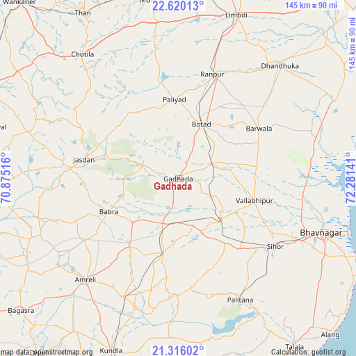
Gadhada GPS coordinates[2]
21° 58' 10.452" North, 71° 34' 41.808" East
| Map corner | latitude | longitude |
|---|---|---|
| Upper-left | 22.62013°, | 70.87516° |
| Center: | 21.96957°, | 71.57828° |
| Lower-right: | 21.31602°, | 72.28141° |
| Map W x H: | 145×145 km | = 90.1×90.1mi |
| max Lat: | 34.9274° ⇑56.8% North |
| Gadhada: | 21.96957° |
| min Lat: | ⇓43.2% South 8.09008° |
| min Long | Gadhada | max Long |
| 68.82655° | 71.57828° | 96.81° |
| W 2.1%⇐ | ⇒97.9% E |
Elevation
Elevation of Gadhada is 89 m = 292 ft, and this is 206.6 m = 678 ft below average elevation for this country.
| Max E: |
3681 m = 12077 ft | 70.8% |
| Avg. | 295.6 m = 970 ft | |
| Gadhada | 89 m = 292 ft | |
Min E: |
1 m = 3 ft | 29.2% |
See also: India elevation on elevation.city.
Geographical zone
Gadhada is located in North Torrid zone (between Equator and Tropic of Cancer). Distance of this Northern Tropic circle is 163.1 km =101.3 mi to North.| Distance of | km | miles | from Gadhada |
|---|---|---|---|
| North Pole | 7564.3 | 4700.2 | to North |
| Arctic Circle | 4958.4 | 3081 | to North |
| Tropic Cancer | 163.1 | 101.3 | to North |
| Equator | 2442.8 | 1517.9 | to South |


Nearby cities:
15 places around Gadhada: (largest is in red/bold)
• Amreli
55.9 km =34.7 mi,  222°
222°
• Botād
24 km =14.9 mi,  22°
22°
• Bābra
31.3 km =19.4 mi,  243°
243°
• Dhola
22.3 km =13.9 mi,  116°
116°
• Dāmnagar
31.5 km =19.6 mi,  191°
191°
• Gariadhar
47.9 km =29.8 mi,  180°
180°
• Jasdan
38.9 km =24.2 mi,  281°
281°
• Lāthi
33.7 km =20.9 mi, 215°
• Pālitāna
55.5 km =34.5 mi,  152°
152°
• Pāliyād
32.1 km =19.9 mi,  356°
356°
• Sihor
48.9 km =30.4 mi,  125°
125°
• Umrāla
27.1 km =16.8 mi, 121°
• Valabhīpur
32.3 km =20.1 mi,  106°
106°
• Vartej
56.4 km =35 mi, 116°
• Vinchia
33.7 km =20.9 mi,  322°
322°
Sources, notices
• [Note1] Compared only with cities in India existing in our database
• [Src1] Map data: © OpenStreetMap contributors (CC-BY-SA)
• [Src2] Other city data from geonames.org with taken over terms of usage.
• [Src3] Geographical zone / Annual Mean Temperature by Robert A. Rohde @ Wikipedia
