Gariāband geodata
Gariāband (Chhattisgarh) is a seat of a second-order administrative division; located in India in Asia/Kolkata (GMT+5.5) time zone. With population of 10,416 people, there are 2900 cities with bigger population in this country. Compared to other cities in India, 63.3% of cities are located further ↑North; 76.8% of cities are located further ←West and 71.9% of cities have lower elevation than Gariāband. Note1


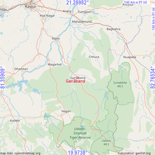
Gariāband GPS coordinates[2]
20° 37' 59.628" North, 82° 3' 43.956" East
| Map corner | latitude | longitude |
|---|---|---|
| Upper-left | 21.28982°, | 81.35909° |
| Center: | 20.63323°, | 82.06221° |
| Lower-right: | 19.9738°, | 82.76534° |
| Map W x H: | 146.3×146.3 km | = 90.9×90.9mi |
| max Lat: | 34.9274° ⇑63.3% North |
| Gariāband: | 20.63323° |
| min Lat: | ⇓36.7% South 8.09008° |
| min Long | Gariāband | max Long |
| 68.82655° | 82.06221° | 96.81° |
| W 76.8%⇐ | ⇒23.2% E |
Elevation
Elevation of Gariāband is 348 m = 1142 ft, and this is 52.4 m = 172 ft above average elevation for this country.
| Max E: |
3681 m = 12077 ft | 28.1% |
| Gariāband | 348 m 1142 ft | |
| Avg. | 295.6 m = 970 ft | |
Min E: |
1 m = 3 ft | 71.9% |
See also: India elevation on elevation.city.
Geographical zone
Gariāband is located in North Torrid zone (between Equator and Tropic of Cancer). Distance of this Northern Tropic circle is 311.7 km =193.7 mi to North.| Distance of | km | miles | from Gariāband |
|---|---|---|---|
| North Pole | 7712.9 | 4792.6 | to North |
| Arctic Circle | 5107 | 3173.3 | to North |
| Tropic Cancer | 311.7 | 193.7 | to North |
| Equator | 2294.2 | 1425.5 | to South |


Nearby cities:
15 places around Gariāband: (largest is in red/bold)
• Arang
63.4 km =39.4 mi,  351°
351°
• Balod
89.7 km =55.7 mi,  276°
276°
• Bhatgaon
68.7 km =42.7 mi,  326°
326°
• Dhamtari
54 km =33.6 mi, 278°
• Kantābānji
91.2 km =56.7 mi,  101°
101°
• Khamharia
42.9 km =26.7 mi,  27°
27°
• Kharhiāl
82.2 km =51.1 mi,  117°
117°
• Kumhāri
90.4 km =56.2 mi,  321°
321°
• Kurud
41.6 km =25.8 mi,  301°
301°
• Kānker
71.7 km =44.6 mi,  235°
235°
• Mahāsamund
52.8 km =32.8 mi,  3°
3°
• Narharpur
50.4 km =31.3 mi,  246°
246°
• Pithora
83.3 km =51.8 mi, 34°
• Pātan
70.7 km =43.9 mi,  308°
308°
• Raipur
80.2 km =49.8 mi, 326°
Sources, notices
• [Note1] Compared only with cities in India existing in our database
• [Src1] Map data: © OpenStreetMap contributors (CC-BY-SA)
• [Src2] Other city data from geonames.org with taken over terms of usage.
• [Src3] Geographical zone / Annual Mean Temperature by Robert A. Rohde @ Wikipedia
