Pithora geodata
Pithora (Chhattisgarh) is a populated place; located in India in Asia/Kolkata (GMT+5.5) time zone. With population of 7,592 people, there are 3164 cities with bigger population in this country. Compared to other cities in India, 60.3% of cities are located further ↑North; 77.9% of cities are located further ←West and 67% of cities have lower elevation than Pithora. Note1


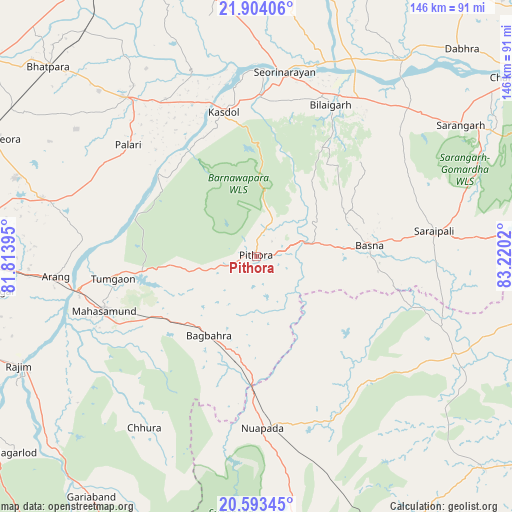
Pithora GPS coordinates[2]
21° 15' 0.756" North, 82° 31' 1.452" East
| Map corner | latitude | longitude |
|---|---|---|
| Upper-left | 21.90406°, | 81.81395° |
| Center: | 21.25021°, | 82.51707° |
| Lower-right: | 20.59345°, | 83.2202° |
| Map W x H: | 145.7×145.7 km | = 90.5×90.5mi |
| max Lat: | 34.9274° ⇑60.3% North |
| Pithora: | 21.25021° |
| min Lat: | ⇓39.7% South 8.09008° |
| min Long | Pithora | max Long |
| 68.82655° | 82.51707° | 96.81° |
| W 77.9%⇐ | ⇒22.1% E |
Elevation
Elevation of Pithora is 301 m = 988 ft, and this is 5.4 m = 18 ft above average elevation for this country.
| Max E: |
3681 m = 12077 ft | 33% |
| Pithora | 301 m 988 ft | |
| Avg. | 295.6 m = 970 ft | |
Min E: |
1 m = 3 ft | 67% |
See also: India elevation on elevation.city.
Geographical zone
Pithora is located in North Torrid zone (between Equator and Tropic of Cancer). Distance of this Northern Tropic circle is 243.1 km =151.1 mi to North.| Distance of | km | miles | from Pithora |
|---|---|---|---|
| North Pole | 7644.3 | 4749.9 | to North |
| Arctic Circle | 5038.4 | 3130.7 | to North |
| Tropic Cancer | 243.1 | 151.1 | to North |
| Equator | 2362.8 | 1468.2 | to South |


Nearby cities:
15 places around Pithora: (largest is in red/bold)
• Arang
57.1 km =35.5 mi,  263°
263°
• Baloda Bāzār
58.3 km =36.2 mi,  320°
320°
• Basna
32.2 km =20 mi,  84°
84°
• Bhatgaon
85.4 km =53.1 mi, 262°
• Bhātāpāra
79.9 km =49.6 mi,  312°
312°
• Deori
24.5 km =15.2 mi,  24°
24°
• Gariāband
83.3 km =51.8 mi,  214°
214°
• Jānjgīr
84.6 km =52.6 mi,  4°
4°
• Khamharia
41.1 km =25.5 mi,  222°
222°
• Kharod
55.3 km =34.4 mi,  6°
6°
• Mahāsamund
46.6 km =29 mi,  250°
250°
• Padampur
63.1 km =39.2 mi,  116°
116°
• Saraipali
51.2 km =31.8 mi, 81°
• Seorīnārāyan
52.9 km =32.9 mi, 8°
• Sārangarh
69.1 km =42.9 mi,  57°
57°
Sources, notices
• [Note1] Compared only with cities in India existing in our database
• [Src1] Map data: © OpenStreetMap contributors (CC-BY-SA)
• [Src2] Other city data from geonames.org with taken over terms of usage.
• [Src3] Geographical zone / Annual Mean Temperature by Robert A. Rohde @ Wikipedia
