Kharhiāl geodata
Kharhiāl (Odisha) is a populated place; located in India in Asia/Kolkata (GMT+5.5) time zone. With population of 14,007 people, there are 2566 cities with bigger population in this country. Compared to other cities in India, 64.3% of cities are located further ↑North; 78.7% of cities are located further ←West and 58.9% of cities have lower elevation than Kharhiāl. Note1


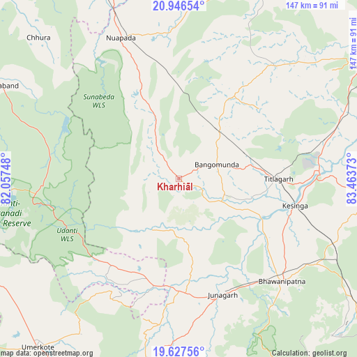
Kharhiāl GPS coordinates[2]
20° 17' 18.42" North, 82° 45' 38.16" East
| Map corner | latitude | longitude |
|---|---|---|
| Upper-left | 20.94654°, | 82.05748° |
| Center: | 20.28845°, | 82.7606° |
| Lower-right: | 19.62756°, | 83.46373° |
| Map W x H: | 146.7×146.7 km | = 91.2×91.2mi |
| max Lat: | 34.9274° ⇑64.3% North |
| Kharhiāl: | 20.28845° |
| min Lat: | ⇓35.7% South 8.09008° |
| min Long | Kharhiāl | max Long |
| 68.82655° | 82.7606° | 96.81° |
| W 78.7%⇐ | ⇒21.3% E |
Elevation
Elevation of Kharhiāl is 244 m = 801 ft, and this is 51.6 m = 169 ft below average elevation for this country.
| Max E: |
3681 m = 12077 ft | 41.1% |
| Avg. | 295.6 m = 970 ft | |
| Kharhiāl | 244 m = 801 ft | |
Min E: |
1 m = 3 ft | 58.9% |
See also: India elevation on elevation.city.
Geographical zone
Kharhiāl is located in North Torrid zone (between Equator and Tropic of Cancer). Distance of this Northern Tropic circle is 350.1 km =217.5 mi to North.| Distance of | km | miles | from Kharhiāl |
|---|---|---|---|
| North Pole | 7751.2 | 4816.4 | to North |
| Arctic Circle | 5145.3 | 3197.1 | to North |
| Tropic Cancer | 350.1 | 217.5 | to North |
| Equator | 2255.9 | 1401.8 | to South |


Nearby cities:
15 places around Kharhiāl: (largest is in red/bold)
• Balāngīr
89 km =55.3 mi,  58°
58°
• Basna
110.3 km =68.5 mi,  3°
3°
• Bhawānipatna
60 km =37.3 mi,  134°
134°
• Gariāband
82.2 km =51.1 mi,  297°
297°
• Jūnāgarh
51 km =31.7 mi,  159°
159°
• Kantābānji
25.9 km =16.1 mi,  39°
39°
• Kesinga
49.2 km =30.6 mi,  103°
103°
• Khamharia
93 km =57.8 mi,  325°
325°
• Mahāsamund
114.4 km =71.1 mi,  322°
322°
• Padampur
85.1 km =52.9 mi,  21°
21°
• Patnāgarh
60.7 km =37.7 mi, 39°
• Pithora
109.9 km =68.3 mi,  346°
346°
• Tarabha
107.2 km =66.6 mi, 62°
• Titlāgarh
40.9 km =25.4 mi,  89°
89°
• Umarkot
90.3 km =56.1 mi,  219°
219°
Sources, notices
• [Note1] Compared only with cities in India existing in our database
• [Src1] Map data: © OpenStreetMap contributors (CC-BY-SA)
• [Src2] Other city data from geonames.org with taken over terms of usage.
• [Src3] Geographical zone / Annual Mean Temperature by Robert A. Rohde @ Wikipedia
