Pāndātarai geodata
Pāndātarai (Chhattisgarh) is a populated place; located in India in Asia/Kolkata (GMT+5.5) time zone. With population of 11,000 people, there are 2832 cities with bigger population in this country. Compared to other cities in India, 55.4% of cities are located further ↑North; 74.1% of cities are located further ←West and 72.6% of cities have lower elevation than Pāndātarai. Note1


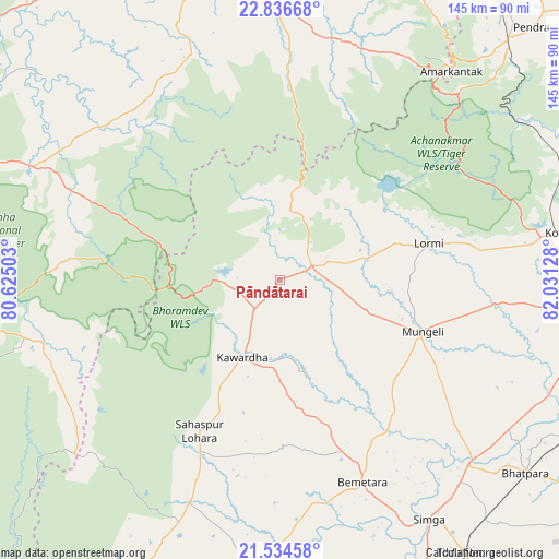
Pāndātarai GPS coordinates[2]
22° 11' 13.704" North, 81° 19' 41.34" East
| Map corner | latitude | longitude |
|---|---|---|
| Upper-left | 22.83668°, | 80.62503° |
| Center: | 22.18714°, | 81.32815° |
| Lower-right: | 21.53458°, | 82.03128° |
| Map W x H: | 144.8×144.8 km | = 90×90mi |
| max Lat: | 34.9274° ⇑55.4% North |
| Pāndātarai: | 22.18714° |
| min Lat: | ⇓44.6% South 8.09008° |
| min Long | Pāndātarai | max Long |
| 68.82655° | 81.32815° | 96.81° |
| W 74.1%⇐ | ⇒25.9% E |
Elevation
Elevation of Pāndātarai is 357 m = 1171 ft, and this is 61.4 m = 201 ft above average elevation for this country.
| Max E: |
3681 m = 12077 ft | 27.4% |
| Pāndātarai | 357 m 1171 ft | |
| Avg. | 295.6 m = 970 ft | |
Min E: |
1 m = 3 ft | 72.6% |
See also: India elevation on elevation.city.
Geographical zone
Pāndātarai is located in North Torrid zone (between Equator and Tropic of Cancer). Distance of this Northern Tropic circle is 138.9 km =86.3 mi to North.| Distance of | km | miles | from Pāndātarai |
|---|---|---|---|
| North Pole | 7540.1 | 4685.2 | to North |
| Arctic Circle | 4934.2 | 3066 | to North |
| Tropic Cancer | 138.9 | 86.3 | to North |
| Equator | 2467 | 1532.9 | to South |


Nearby cities:
15 places around Pāndātarai: (largest is in red/bold)
• Amarkantak
70 km =43.5 mi,  39°
39°
• Baihar
80.7 km =50.1 mi,  263°
263°
• Bemetāra
56.6 km =35.2 mi,  157°
157°
• Bhātāpāra
81.2 km =50.5 mi,  128°
128°
• Bilāspur
86 km =53.4 mi,  97°
97°
• Chhuīkhadān
81.3 km =50.5 mi,  204°
204°
• Gandai
62.5 km =38.8 mi, 202°
• Gaurela
86.3 km =53.6 mi, 43°
• Kawardha
22.2 km =13.8 mi,  206°
206°
• Kotā
72.6 km =45.1 mi,  80°
80°
• Lormi
39.7 km =24.7 mi, 75°
• Mungeli
39.2 km =24.4 mi,  110°
110°
• Pandaria
9.4 km =5.8 mi,  63°
63°
• Simga
73.2 km =45.5 mi,  148°
148°
• Takhatpur
56.1 km =34.9 mi, 96°
Sources, notices
• [Note1] Compared only with cities in India existing in our database
• [Src1] Map data: © OpenStreetMap contributors (CC-BY-SA)
• [Src2] Other city data from geonames.org with taken over terms of usage.
• [Src3] Geographical zone / Annual Mean Temperature by Robert A. Rohde @ Wikipedia
