Farīdpur geodata
Farīdpur (Uttar Pradesh) is a populated place; located in India in Asia/Kolkata (GMT+5.5) time zone. With population of 71,783 people, there are 608 cities with bigger population in this country. Compared to other cities in India, 85.4% of cities are located further ↓South; 64.1% of cities are located further ←West and 56% of cities have higher elevation than Farīdpur. Note1


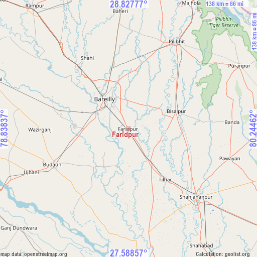
Farīdpur GPS coordinates[2]
28° 12' 35.892" North, 79° 32' 29.364" East
| Map corner | latitude | longitude |
|---|---|---|
| Upper-left | 28.82777°, | 78.83837° |
| Center: | 28.20997°, | 79.54149° |
| Lower-right: | 27.58857°, | 80.24462° |
| Map W x H: | 137.8×137.8 km | = 85.6×85.6mi |
| max Lat: | 34.9274° ⇑14.6% North |
| Farīdpur: | 28.20997° |
| min Lat: | ⇓85.4% South 8.09008° |
| min Long | Farīdpur | max Long |
| 68.82655° | 79.54149° | 96.81° |
| W 64.1%⇐ | ⇒35.9% E |
Elevation
Elevation of Farīdpur is 170 m = 558 ft, and this is 125.6 m = 412 ft below average elevation for this country.
| Max E: |
3681 m = 12077 ft | 56% |
| Avg. | 295.6 m = 970 ft | |
| Farīdpur | 170 m = 558 ft | |
Min E: |
1 m = 3 ft | 44% |
See also: Farīdpur elevation on elevation.city.
Geographical zone
Farīdpur is located in North temperate zone (between Tropic of Cancer and the Arctic Circle). Distance of this Northern Tropic circle is 530.7 km =329.8 mi to South.| Distance of | km | miles | from Farīdpur |
|---|---|---|---|
| North Pole | 6870.4 | 4269.1 | to North |
| Arctic Circle | 4264.5 | 2649.8 | to North |
| Tropic Cancer | 530.7 | 329.8 | to South |
| Equator | 3136.7 | 1949.1 | to South |


Nearby cities:
15 places around Farīdpur: (largest is in red/bold)
• Aonla
37.5 km =23.3 mi,  280°
280°
• Bareilly
20.5 km =12.7 mi,  328°
328°
• Barkhera Kalān
37.4 km =23.2 mi,  43°
43°
• Bilsanda
40.3 km =25 mi,  84°
84°
• Budaun
44.9 km =27.9 mi,  244°
244°
• Bīsalpur
27.4 km =17 mi,  70°
70°
• Deoraniān
47.1 km =29.3 mi,  352°
352°
• Dātāganj
24.3 km =15.1 mi,  212°
212°
• Fatehganj West
36.6 km =22.7 mi,  321°
321°
• Khudāganj
18.4 km =11.4 mi,  112°
112°
• Mīrānpur Katra
23.6 km =14.7 mi,  148°
148°
• Nawābganj
37.9 km =23.5 mi,  13°
13°
• Shāhi
43.7 km =27.2 mi, 329°
• Tilhar
33.6 km =20.9 mi,  144°
144°
• Wazīrganj
47.5 km =29.5 mi,  270°
270°
Sources, notices
• [Note1] Compared only with cities in India existing in our database
• [Src1] Map data: © OpenStreetMap contributors (CC-BY-SA)
• [Src2] Other city data from geonames.org with taken over terms of usage.
• [Src3] Geographical zone / Annual Mean Temperature by Robert A. Rohde @ Wikipedia
